You are here: Home > Network List > TA - USArray Transportable Network (new EarthScope stations) Stations List
> Station Z36A Blue Ridge, TX, USA > Earthquake Result Viewer
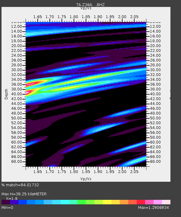
Z36A Blue Ridge, TX, USA - Earthquake Result Viewer
| Earthquake location: |
Ecuador |
| Earthquake latitude/longitude: |
-1.3/-77.3 |
| Earthquake time(UTC): |
2010/08/12 (224) 11:54:15 GMT |
| Earthquake Depth: |
207 km |
| Earthquake Magnitude: |
6.4 MB, 7.1 MW, 7.1 MW |
| Earthquake Catalog/Contributor: |
WHDF/NEIC |
|
| Network: |
TA USArray Transportable Network (new EarthScope stations) |
| Station: |
Z36A Blue Ridge, TX, USA |
| Lat/Lon: |
33.27 N/96.43 W |
| Elevation: |
187 m |
|
| Distance: |
38.8 deg |
| Az: |
334.016 deg |
| Baz: |
148.477 deg |
| Ray Param: |
0.07455664 |
| Estimated Moho Depth: |
39.25 km |
| Estimated Crust Vp/Vs: |
1.60 |
| Assumed Crust Vp: |
6.38 km/s |
| Estimated Crust Vs: |
3.988 km/s |
| Estimated Crust Poisson's Ratio: |
0.18 |
|
| Radial Match: |
94.01732 % |
| Radial Bump: |
400 |
| Transverse Match: |
79.61837 % |
| Transverse Bump: |
400 |
| SOD ConfigId: |
319893 |
| Insert Time: |
2011-01-05 20:57:41.631 +0000 |
| GWidth: |
2.5 |
| Max Bumps: |
400 |
| Tol: |
0.001 |
|

Signal To Noise
| Channel | StoN | STA | LTA |
| TA:Z36A: :BHZ:20100812T12:00:49.724989Z | 26.317225 | 3.1268135E-6 | 1.1881243E-7 |
| TA:Z36A: :BHN:20100812T12:00:49.724989Z | 10.354506 | 1.5154054E-6 | 1.4635226E-7 |
| TA:Z36A: :BHE:20100812T12:00:49.724989Z | 7.3568344 | 1.0637228E-6 | 1.4458975E-7 |
| Arrivals |
| Ps | 4.0 SECOND |
| PpPs | 15 SECOND |
| PsPs/PpSs | 19 SECOND |


