You are here: Home > Network List > TA - USArray Transportable Network (new EarthScope stations) Stations List
> Station N33A J Bar K, Exeter, NE, USA > Earthquake Result Viewer
N33A J Bar K, Exeter, NE, USA - Earthquake Result Viewer

| Earthquake location: |
Ecuador |
| Earthquake latitude/longitude: |
-1.3/-77.3 |
| Earthquake time(UTC): |
2010/08/12 (224) 11:54:15 GMT |
| Earthquake Depth: |
207 km |
| Earthquake Magnitude: |
6.4 MB, 7.1 MW, 7.1 MW |
| Earthquake Catalog/Contributor: |
WHDF/NEIC |
|
| Network: |
TA USArray Transportable Network (new EarthScope stations) |
| Station: |
N33A J Bar K, Exeter, NE, USA |
| Lat/Lon: |
40.74 N/97.45 W |
| Elevation: |
475 m |
|
| Distance: |
45.7 deg |
| Az: |
338.537 deg |
| Baz: |
151.221 deg |
| Ray Param: |
0.07035186 |
| Estimated Moho Depth: |
52.0 km |
| Estimated Crust Vp/Vs: |
1.67 |
| Assumed Crust Vp: |
6.498 km/s |
| Estimated Crust Vs: |
3.891 km/s |
| Estimated Crust Poisson's Ratio: |
0.22 |
|
| Radial Match: |
96.57125 % |
| Radial Bump: |
400 |
| Transverse Match: |
83.02243 % |
| Transverse Bump: |
400 |
| SOD ConfigId: |
319893 |
| Insert Time: |
2011-01-05 20:58:30.412 +0000 |
| GWidth: |
2.5 |
| Max Bumps: |
400 |
| Tol: |
0.001 |
|
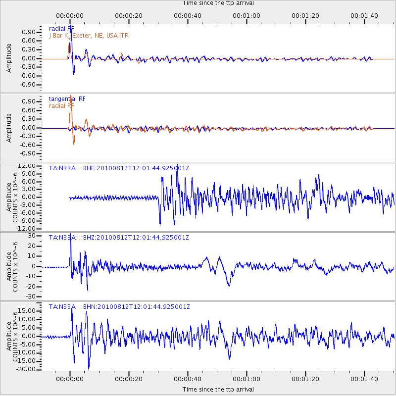
Signal To Noise
| Channel | StoN | STA | LTA |
| TA:N33A: :BHZ:20100812T12:01:44.925001Z | 69.182785 | 8.916503E-6 | 1.2888327E-7 |
| TA:N33A: :BHN:20100812T12:01:44.925001Z | 25.381186 | 6.8182367E-6 | 2.686335E-7 |
| TA:N33A: :BHE:20100812T12:01:44.925001Z | 11.891276 | 4.4434787E-6 | 3.736755E-7 |
| Arrivals |
| Ps | 5.7 SECOND |
| PpPs | 20 SECOND |
| PsPs/PpSs | 26 SECOND |


