You are here: Home > Network List > TA - USArray Transportable Network (new EarthScope stations) Stations List
> Station K32A Verdigre, NE, USA > Earthquake Result Viewer
K32A Verdigre, NE, USA - Earthquake Result Viewer
| Earthquake location: |
Ecuador |
| Earthquake latitude/longitude: |
-1.3/-77.3 |
| Earthquake time(UTC): |
2010/08/12 (224) 11:54:15 GMT |
| Earthquake Depth: |
207 km |
| Earthquake Magnitude: |
6.4 MB, 7.1 MW, 7.1 MW |
| Earthquake Catalog/Contributor: |
WHDF/NEIC |
|
| Network: |
TA USArray Transportable Network (new EarthScope stations) |
| Station: |
K32A Verdigre, NE, USA |
| Lat/Lon: |
42.66 N/97.97 W |
| Elevation: |
512 m |
|
| Distance: |
47.5 deg |
| Az: |
339.333 deg |
| Baz: |
151.423 deg |
| Ray Param: |
0.069163226 |
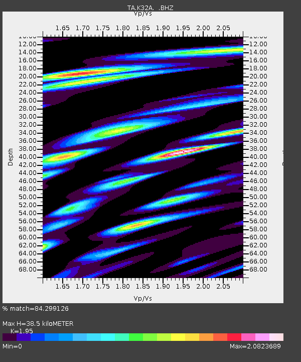
| Estimated Moho Depth: |
38.5 km |
| Estimated Crust Vp/Vs: |
1.95 |
| Assumed Crust Vp: |
6.498 km/s |
| Estimated Crust Vs: |
3.332 km/s |
| Estimated Crust Poisson's Ratio: |
0.32 |
|
| Radial Match: |
84.299126 % |
| Radial Bump: |
400 |
| Transverse Match: |
75.61681 % |
| Transverse Bump: |
400 |
| SOD ConfigId: |
319893 |
| Insert Time: |
2011-01-05 20:59:06.387 +0000 |
| GWidth: |
2.5 |
| Max Bumps: |
400 |
| Tol: |
0.001 |
|
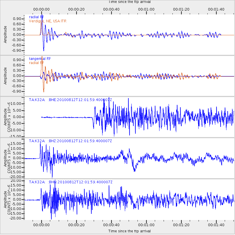
Signal To Noise
| Channel | StoN | STA | LTA |
| TA:K32A: :BHZ:20100812T12:01:59.400007Z | 101.84501 | 7.763263E-6 | 7.622626E-8 |
| TA:K32A: :BHN:20100812T12:01:59.400007Z | 37.95384 | 6.0356124E-6 | 1.5902509E-7 |
| TA:K32A: :BHE:20100812T12:01:59.400007Z | 34.19586 | 4.37111E-6 | 1.278257E-7 |
| Arrivals |
| Ps | 6.0 SECOND |
| PpPs | 17 SECOND |
| PsPs/PpSs | 22 SECOND |


