You are here: Home > Network List > TA - USArray Transportable Network (new EarthScope stations) Stations List
> Station L04D Klamath Falls, OR, USA > Earthquake Result Viewer
L04D Klamath Falls, OR, USA - Earthquake Result Viewer
| Earthquake location: |
Ecuador |
| Earthquake latitude/longitude: |
-1.3/-77.3 |
| Earthquake time(UTC): |
2010/08/12 (224) 11:54:15 GMT |
| Earthquake Depth: |
207 km |
| Earthquake Magnitude: |
6.4 MB, 7.1 MW, 7.1 MW |
| Earthquake Catalog/Contributor: |
WHDF/NEIC |
|
| Network: |
TA USArray Transportable Network (new EarthScope stations) |
| Station: |
L04D Klamath Falls, OR, USA |
| Lat/Lon: |
42.22 N/122.30 W |
| Elevation: |
1437 m |
|
| Distance: |
59.3 deg |
| Az: |
322.351 deg |
| Baz: |
124.705 deg |
| Ray Param: |
0.061602864 |
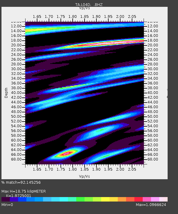
| Estimated Moho Depth: |
18.75 km |
| Estimated Crust Vp/Vs: |
1.97 |
| Assumed Crust Vp: |
6.522 km/s |
| Estimated Crust Vs: |
3.306 km/s |
| Estimated Crust Poisson's Ratio: |
0.33 |
|
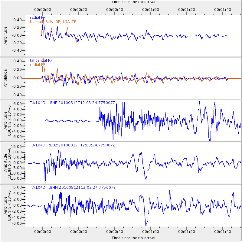
| Radial Match: |
92.145256 % |
| Radial Bump: |
400 |
| Transverse Match: |
84.522125 % |
| Transverse Bump: |
400 |
| SOD ConfigId: |
319893 |
| Insert Time: |
2011-01-05 21:00:15.651 +0000 |
| GWidth: |
2.5 |
| Max Bumps: |
400 |
| Tol: |
0.001 |
|
Signal To Noise
| Channel | StoN | STA | LTA |
| TA:L04D: :BHZ:20100812T12:03:24.775007Z | 32.880447 | 5.914435E-6 | 1.7987696E-7 |
| TA:L04D: :BHN:20100812T12:03:24.775007Z | 6.161501 | 1.1870663E-6 | 1.9265863E-7 |
| TA:L04D: :BHE:20100812T12:03:24.775007Z | 8.274046 | 1.8711143E-6 | 2.261426E-7 |
| Arrivals |
| Ps | 2.9 SECOND |
| PpPs | 8.2 SECOND |
| PsPs/PpSs | 11 SECOND |


