You are here: Home > Network List > IM - International Miscellaneous Stations Stations List
> Station MK31 Makanchi Array Site 31, Kazakhstan > Earthquake Result Viewer
MK31 Makanchi Array Site 31, Kazakhstan - Earthquake Result Viewer
| Earthquake location: |
Eastern Gulf Of Aden |
| Earthquake latitude/longitude: |
12.3/47.4 |
| Earthquake time(UTC): |
2023/12/05 (339) 07:31:33 GMT |
| Earthquake Depth: |
10 km |
| Earthquake Magnitude: |
5.6 mww |
| Earthquake Catalog/Contributor: |
NEIC PDE/us |
|
| Network: |
IM International Miscellaneous Stations |
| Station: |
MK31 Makanchi Array Site 31, Kazakhstan |
| Lat/Lon: |
46.79 N/82.29 E |
| Elevation: |
618 m |
|
| Distance: |
45.2 deg |
| Az: |
33.597 deg |
| Baz: |
231.922 deg |
| Ray Param: |
0.07144787 |
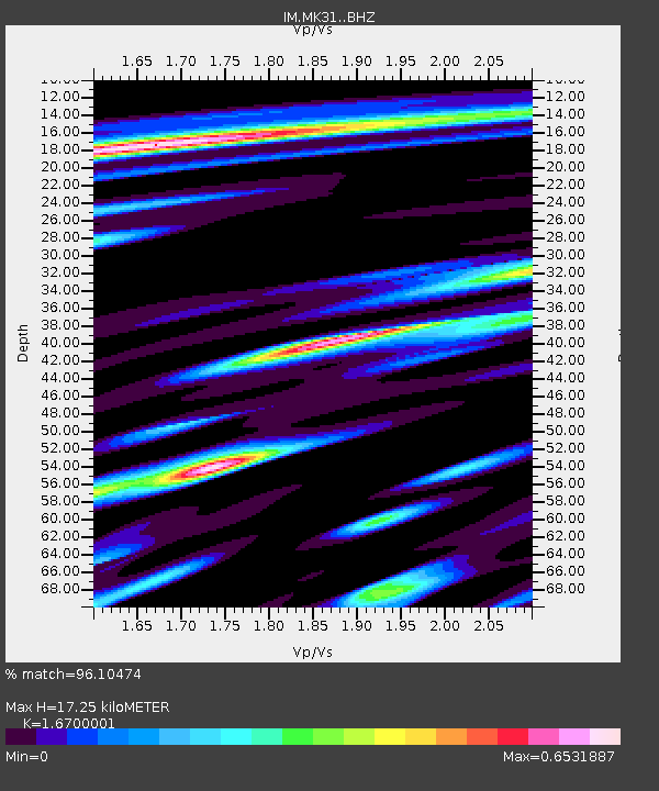
| Estimated Moho Depth: |
17.25 km |
| Estimated Crust Vp/Vs: |
1.67 |
| Assumed Crust Vp: |
6.688 km/s |
| Estimated Crust Vs: |
4.005 km/s |
| Estimated Crust Poisson's Ratio: |
0.22 |
|
| Radial Match: |
96.10474 % |
| Radial Bump: |
400 |
| Transverse Match: |
92.70669 % |
| Transverse Bump: |
400 |
| SOD ConfigId: |
33232451 |
| Insert Time: |
2023-12-19 07:37:02.445 +0000 |
| GWidth: |
2.5 |
| Max Bumps: |
400 |
| Tol: |
0.001 |
|

Signal To Noise
| Channel | StoN | STA | LTA |
| IM:MK31: :BHZ:20231205T07:39:19.999999Z | 32.02174 | 8.132851E-8 | 2.5397904E-9 |
| IM:MK31: :BHN:20231205T07:39:19.999999Z | 17.71223 | 2.8861457E-8 | 1.6294648E-9 |
| IM:MK31: :BHE:20231205T07:39:19.999999Z | 16.210506 | 2.8396324E-8 | 1.7517235E-9 |
| Arrivals |
| Ps | 1.9 SECOND |
| PpPs | 6.4 SECOND |
| PsPs/PpSs | 8.3 SECOND |


