You are here: Home > Network List > TA - USArray Transportable Network (new EarthScope stations) Stations List
> Station O03D Paynes Creek, CA, USA > Earthquake Result Viewer
O03D Paynes Creek, CA, USA - Earthquake Result Viewer
| Earthquake location: |
Ecuador |
| Earthquake latitude/longitude: |
-1.3/-77.3 |
| Earthquake time(UTC): |
2010/08/12 (224) 11:54:15 GMT |
| Earthquake Depth: |
207 km |
| Earthquake Magnitude: |
6.4 MB, 7.1 MW, 7.1 MW |
| Earthquake Catalog/Contributor: |
WHDF/NEIC |
|
| Network: |
TA USArray Transportable Network (new EarthScope stations) |
| Station: |
O03D Paynes Creek, CA, USA |
| Lat/Lon: |
40.29 N/121.80 W |
| Elevation: |
968 m |
|
| Distance: |
57.9 deg |
| Az: |
320.746 deg |
| Baz: |
124.199 deg |
| Ray Param: |
0.062509336 |
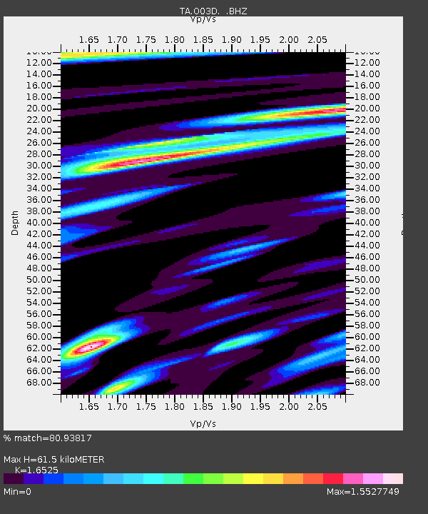
| Estimated Moho Depth: |
61.5 km |
| Estimated Crust Vp/Vs: |
1.65 |
| Assumed Crust Vp: |
6.566 km/s |
| Estimated Crust Vs: |
3.973 km/s |
| Estimated Crust Poisson's Ratio: |
0.21 |
|
| Radial Match: |
80.93817 % |
| Radial Bump: |
400 |
| Transverse Match: |
70.92251 % |
| Transverse Bump: |
400 |
| SOD ConfigId: |
319893 |
| Insert Time: |
2011-01-05 21:00:40.086 +0000 |
| GWidth: |
2.5 |
| Max Bumps: |
400 |
| Tol: |
0.001 |
|
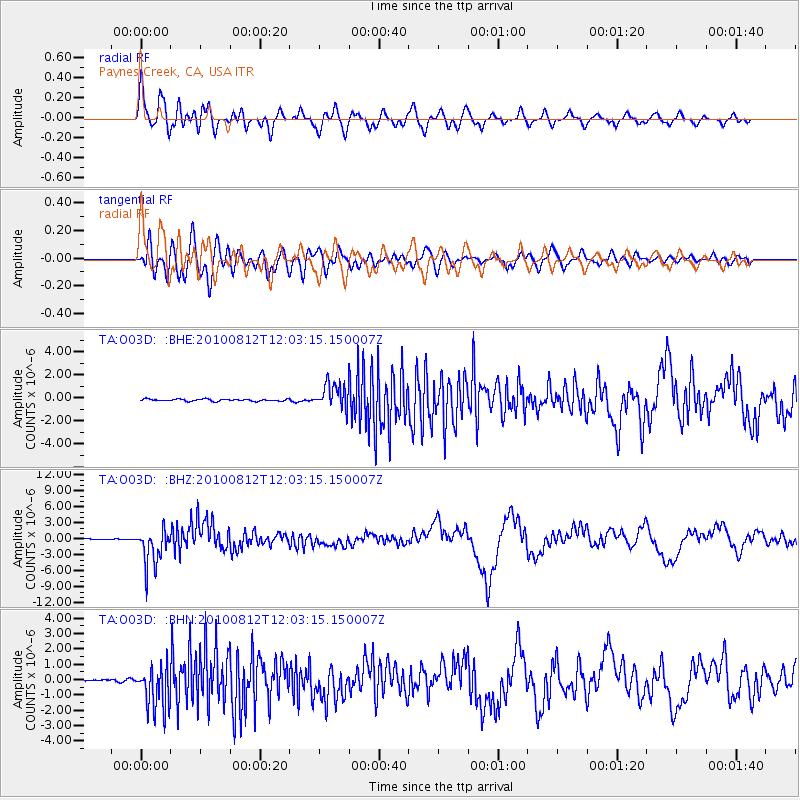
Signal To Noise
| Channel | StoN | STA | LTA |
| TA:O03D: :BHZ:20100812T12:03:15.150007Z | 42.960987 | 3.4635957E-6 | 8.062188E-8 |
| TA:O03D: :BHN:20100812T12:03:15.150007Z | 22.16873 | 1.4309283E-6 | 6.4547145E-8 |
| TA:O03D: :BHE:20100812T12:03:15.150007Z | 12.534808 | 1.0987691E-6 | 8.765743E-8 |
| Arrivals |
| Ps | 6.5 SECOND |
| PpPs | 24 SECOND |
| PsPs/PpSs | 30 SECOND |


