You are here: Home > Network List > US - United States National Seismic Network Stations List
> Station TZTN Tazewell, Tennessee, USA > Earthquake Result Viewer
TZTN Tazewell, Tennessee, USA - Earthquake Result Viewer

| Earthquake location: |
Ecuador |
| Earthquake latitude/longitude: |
-1.3/-77.3 |
| Earthquake time(UTC): |
2010/08/12 (224) 11:54:15 GMT |
| Earthquake Depth: |
207 km |
| Earthquake Magnitude: |
6.4 MB, 7.1 MW, 7.1 MW |
| Earthquake Catalog/Contributor: |
WHDF/NEIC |
|
| Network: |
US United States National Seismic Network |
| Station: |
TZTN Tazewell, Tennessee, USA |
| Lat/Lon: |
36.54 N/83.55 W |
| Elevation: |
394 m |
|
| Distance: |
38.1 deg |
| Az: |
351.834 deg |
| Baz: |
169.843 deg |
| Ray Param: |
0.07499029 |
| Estimated Moho Depth: |
34.25 km |
| Estimated Crust Vp/Vs: |
2.07 |
| Assumed Crust Vp: |
6.476 km/s |
| Estimated Crust Vs: |
3.125 km/s |
| Estimated Crust Poisson's Ratio: |
0.35 |
|
| Radial Match: |
95.25592 % |
| Radial Bump: |
400 |
| Transverse Match: |
82.49738 % |
| Transverse Bump: |
400 |
| SOD ConfigId: |
319893 |
| Insert Time: |
2011-01-05 21:03:55.833 +0000 |
| GWidth: |
2.5 |
| Max Bumps: |
400 |
| Tol: |
0.001 |
|
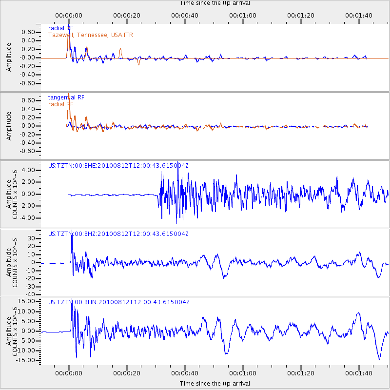
Signal To Noise
| Channel | StoN | STA | LTA |
| US:TZTN:00:BHZ:20100812T12:00:43.615004Z | 92.57966 | 1.0595632E-5 | 1.1444882E-7 |
| US:TZTN:00:BHN:20100812T12:00:43.615004Z | 94.4114 | 6.3678235E-6 | 6.7447615E-8 |
| US:TZTN:00:BHE:20100812T12:00:43.615004Z | 21.55184 | 1.3401462E-6 | 6.218245E-8 |
| Arrivals |
| Ps | 6.0 SECOND |
| PpPs | 15 SECOND |
| PsPs/PpSs | 21 SECOND |


