You are here: Home > Network List > XZ05 - STEEP: St. Elias Erosion and Tectonics Project Stations List
> Station BERG Bagley Icefield > Earthquake Result Viewer
BERG Bagley Icefield - Earthquake Result Viewer
| Earthquake location: |
Ecuador |
| Earthquake latitude/longitude: |
-1.3/-77.3 |
| Earthquake time(UTC): |
2010/08/12 (224) 11:54:15 GMT |
| Earthquake Depth: |
207 km |
| Earthquake Magnitude: |
6.4 MB, 7.1 MW, 7.1 MW |
| Earthquake Catalog/Contributor: |
WHDF/NEIC |
|
| Network: |
XZ STEEP: St. Elias Erosion and Tectonics Project |
| Station: |
BERG Bagley Icefield |
| Lat/Lon: |
60.39 N/143.70 W |
| Elevation: |
474 m |
|
| Distance: |
79.6 deg |
| Az: |
332.448 deg |
| Baz: |
111.366 deg |
| Ray Param: |
0.04830091 |
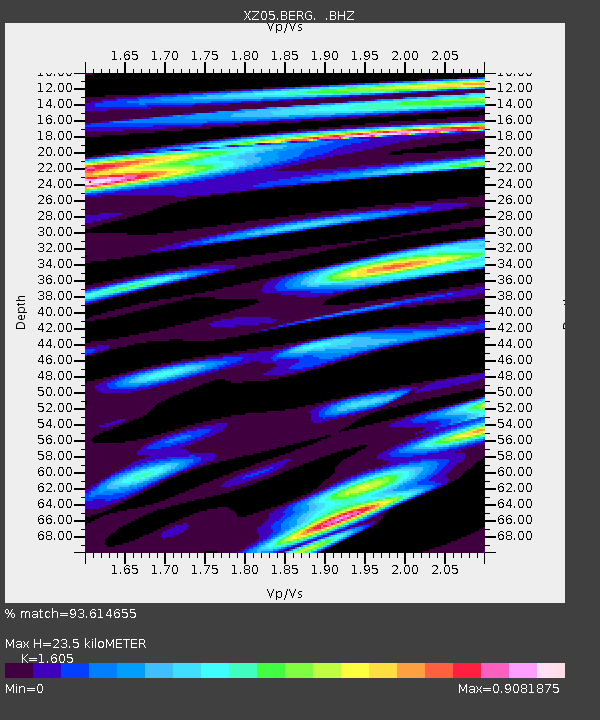
| Estimated Moho Depth: |
23.5 km |
| Estimated Crust Vp/Vs: |
1.61 |
| Assumed Crust Vp: |
6.566 km/s |
| Estimated Crust Vs: |
4.091 km/s |
| Estimated Crust Poisson's Ratio: |
0.18 |
|
| Radial Match: |
93.614655 % |
| Radial Bump: |
400 |
| Transverse Match: |
88.27383 % |
| Transverse Bump: |
400 |
| SOD ConfigId: |
319893 |
| Insert Time: |
2011-01-05 21:07:49.652 +0000 |
| GWidth: |
2.5 |
| Max Bumps: |
400 |
| Tol: |
0.001 |
|

Signal To Noise
| Channel | StoN | STA | LTA |
| XZ:BERG: :BHZ:20100812T12:05:28.767988Z | 31.570257 | 1.7766471E-6 | 5.6275972E-8 |
| XZ:BERG: :BHN:20100812T12:05:28.767988Z | 4.510623 | 5.07341E-7 | 1.1247692E-7 |
| XZ:BERG: :BHE:20100812T12:05:28.767988Z | 3.36471 | 4.4666274E-7 | 1.3274925E-7 |
| Arrivals |
| Ps | 2.2 SECOND |
| PpPs | 9.0 SECOND |
| PsPs/PpSs | 11 SECOND |


