You are here: Home > Network List > AZ - ANZA Regional Network Stations List
> Station PFO AZ.PFO > Earthquake Result Viewer
PFO AZ.PFO - Earthquake Result Viewer
| Earthquake location: |
South Of Mariana Islands |
| Earthquake latitude/longitude: |
12.5/141.5 |
| Earthquake time(UTC): |
2010/08/13 (225) 21:19:33 GMT |
| Earthquake Depth: |
10 km |
| Earthquake Magnitude: |
6.5 MB, 6.9 MS, 6.9 MW, 6.9 MW |
| Earthquake Catalog/Contributor: |
WHDF/NEIC |
|
| Network: |
AZ ANZA Regional Network |
| Station: |
PFO AZ.PFO |
| Lat/Lon: |
33.61 N/116.46 W |
| Elevation: |
1259 m |
|
| Distance: |
93.0 deg |
| Az: |
54.804 deg |
| Baz: |
286.985 deg |
| Ray Param: |
0.041351028 |
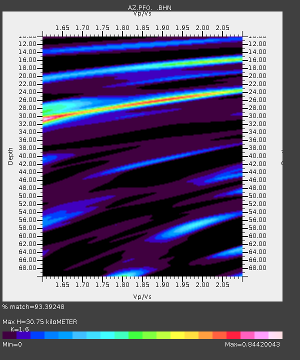
| Estimated Moho Depth: |
30.75 km |
| Estimated Crust Vp/Vs: |
1.60 |
| Assumed Crust Vp: |
6.264 km/s |
| Estimated Crust Vs: |
3.915 km/s |
| Estimated Crust Poisson's Ratio: |
0.18 |
|
| Radial Match: |
93.39248 % |
| Radial Bump: |
389 |
| Transverse Match: |
90.342125 % |
| Transverse Bump: |
400 |
| SOD ConfigId: |
319893 |
| Insert Time: |
2011-01-05 21:10:48.456 +0000 |
| GWidth: |
2.5 |
| Max Bumps: |
400 |
| Tol: |
0.001 |
|

Signal To Noise
| Channel | StoN | STA | LTA |
| AZ:PFO: :BHZ:20100813T21:32:14.874973Z | 7.5391455 | 6.580583E-7 | 8.728553E-8 |
| AZ:PFO: :BHN:20100813T21:32:14.874973Z | 1.6499604 | 1.6676553E-7 | 1.01072445E-7 |
| AZ:PFO: :BHE:20100813T21:32:14.874973Z | 1.5721099 | 2.1057392E-7 | 1.339435E-7 |
| Arrivals |
| Ps | 3.0 SECOND |
| PpPs | 12 SECOND |
| PsPs/PpSs | 16 SECOND |


