You are here: Home > Network List > AZ - ANZA Regional Network Stations List
> Station LVA2 AZ.LVA2 > Earthquake Result Viewer
LVA2 AZ.LVA2 - Earthquake Result Viewer

| Earthquake location: |
South Of Mariana Islands |
| Earthquake latitude/longitude: |
12.5/141.5 |
| Earthquake time(UTC): |
2010/08/13 (225) 21:19:33 GMT |
| Earthquake Depth: |
10 km |
| Earthquake Magnitude: |
6.5 MB, 6.9 MS, 6.9 MW, 6.9 MW |
| Earthquake Catalog/Contributor: |
WHDF/NEIC |
|
| Network: |
AZ ANZA Regional Network |
| Station: |
LVA2 AZ.LVA2 |
| Lat/Lon: |
33.35 N/116.56 W |
| Elevation: |
1435 m |
|
| Distance: |
93.0 deg |
| Az: |
55.078 deg |
| Baz: |
286.914 deg |
| Ray Param: |
0.041352212 |
| Estimated Moho Depth: |
58.25 km |
| Estimated Crust Vp/Vs: |
1.85 |
| Assumed Crust Vp: |
6.264 km/s |
| Estimated Crust Vs: |
3.381 km/s |
| Estimated Crust Poisson's Ratio: |
0.29 |
|
| Radial Match: |
91.04115 % |
| Radial Bump: |
400 |
| Transverse Match: |
79.86478 % |
| Transverse Bump: |
400 |
| SOD ConfigId: |
319893 |
| Insert Time: |
2011-01-05 21:11:25.861 +0000 |
| GWidth: |
2.5 |
| Max Bumps: |
400 |
| Tol: |
0.001 |
|
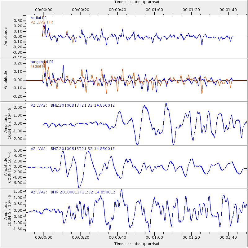
Signal To Noise
| Channel | StoN | STA | LTA |
| AZ:LVA2: :BHZ:20100813T21:32:14.85001Z | 5.643296 | 5.423693E-7 | 9.6108614E-8 |
| AZ:LVA2: :BHN:20100813T21:32:14.85001Z | 0.9326156 | 1.091198E-7 | 1.17004056E-7 |
| AZ:LVA2: :BHE:20100813T21:32:14.85001Z | 0.8175602 | 1.1277569E-7 | 1.3794175E-7 |
| Arrivals |
| Ps | 8.1 SECOND |
| PpPs | 26 SECOND |
| PsPs/PpSs | 34 SECOND |


