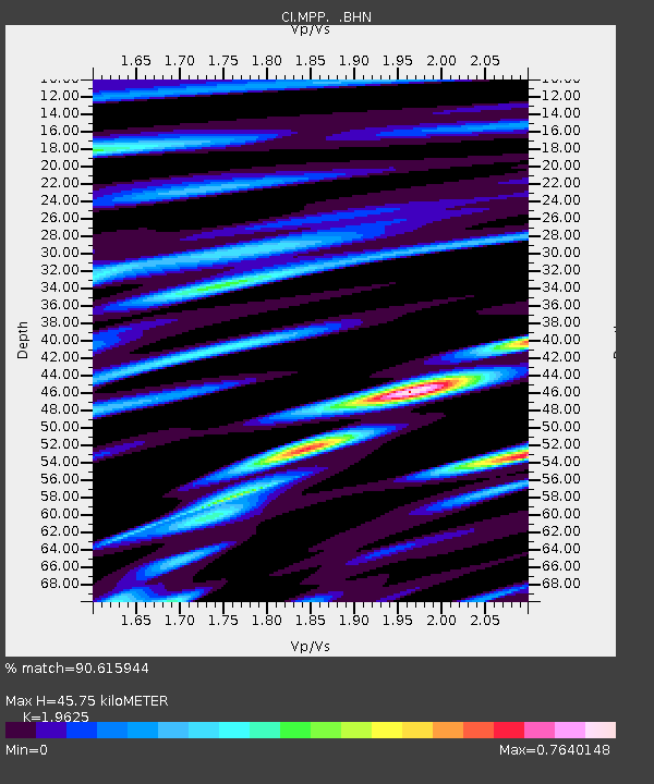
MPP McPhearson Peak - Earthquake Result Viewer
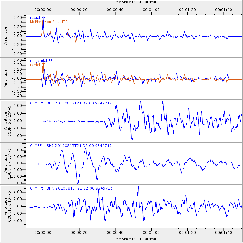
Earthquake location: South Of Mariana Islands
Earthquake latitude/longitude: 12.5/141.5
Earthquake time(UTC): 2010/08/13 (225) 21:19:33 GMT
Earthquake Depth: 10 km
Earthquake Magnitude: 6.5 MB, 6.9 MS, 6.9 MW, 6.9 MW
Earthquake Catalog/Contributor: WHDF/NEIC
Network: CI Caltech Regional Seismic Network
Station: MPP McPhearson Peak
Lat/Lon: 34.89 N/119.81 W
Elevation: 1739 m
Distance: 90.0 deg
Az: 54.349 deg
Baz: 285.117 deg
Ray Param: 0.04170752
Estimated Moho Depth: 45.75 km
Estimated Crust Vp/Vs: 1.96
Assumed Crust Vp: 6.1 km/s
Estimated Crust Vs: 3.108 km/s
Estimated Crust Poisson's Ratio: 0.32
Radial Match: 90.615944 %
Radial Bump: 400
Transverse Match: 87.02278 %
Transverse Bump: 400
SOD ConfigId: 319893
Insert Time: 2011-01-05 21:15:50.419 +0000
GWidth: 2.5
Max Bumps: 400
Tol: 0.001

Signal To Noise

ChannelStoNSTALTA
CI:MPP: :BHZ:20100813T21:32:00.934971Z5.68347266.0592913E-71.0661248E-7
CI:MPP: :BHN:20100813T21:32:00.934971Z0.88175173.1207952E-73.5393126E-7
CI:MPP: :BHE:20100813T21:32:00.934971Z1.8538332.2791613E-71.2294319E-7
Arrivals
Ps7.3 SECOND
PpPs22 SECOND
PsPs/PpSs29 SECOND