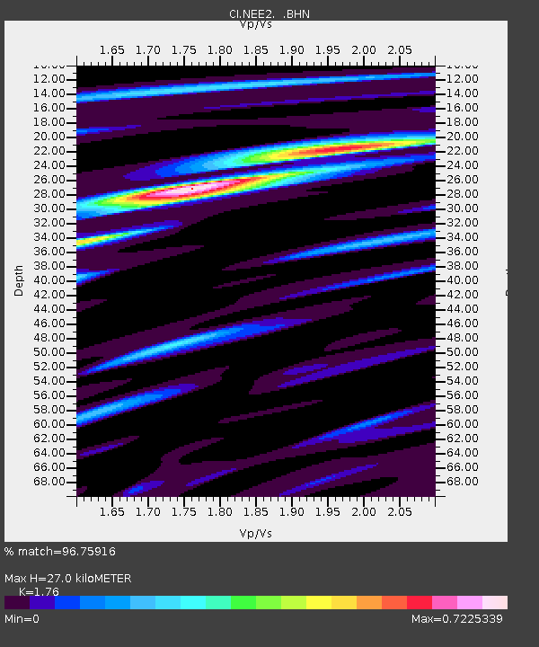
NEE2 Needles Airport - Earthquake Result Viewer
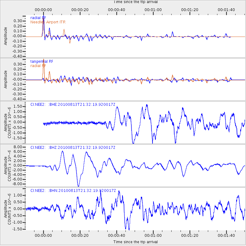
Earthquake location: South Of Mariana Islands
Earthquake latitude/longitude: 12.5/141.5
Earthquake time(UTC): 2010/08/13 (225) 21:19:33 GMT
Earthquake Depth: 10 km
Earthquake Magnitude: 6.5 MB, 6.9 MS, 6.9 MW, 6.9 MW
Earthquake Catalog/Contributor: WHDF/NEIC
Network: CI Caltech Regional Seismic Network
Station: NEE2 Needles Airport
Lat/Lon: 34.77 N/114.62 W
Elevation: 271 m
Distance: 94.1 deg
Az: 53.242 deg
Baz: 288.111 deg
Ray Param: 0.041125312
Estimated Moho Depth: 27.0 km
Estimated Crust Vp/Vs: 1.76
Assumed Crust Vp: 6.276 km/s
Estimated Crust Vs: 3.566 km/s
Estimated Crust Poisson's Ratio: 0.26
Radial Match: 96.75916 %
Radial Bump: 400
Transverse Match: 84.72766 %
Transverse Bump: 400
SOD ConfigId: 319893
Insert Time: 2011-01-05 21:17:26.696 +0000
GWidth: 2.5
Max Bumps: 400
Tol: 0.001

Signal To Noise

ChannelStoNSTALTA
CI:NEE2: :BHZ:20100813T21:32:19.920017Z9.3277235.688155E-76.098118E-8
CI:NEE2: :BHN:20100813T21:32:19.920017Z1.64775191.4519257E-78.8115556E-8
CI:NEE2: :BHE:20100813T21:32:19.920017Z1.82144171.21899E-76.6924464E-8
Arrivals
Ps3.3 SECOND
PpPs12 SECOND
PsPs/PpSs15 SECOND