You are here: Home > Network List > CN - Canadian National Seismograph Network Stations List
> Station RES RESOLUTE, N.W.T. > Earthquake Result Viewer
RES RESOLUTE, N.W.T. - Earthquake Result Viewer
| Earthquake location: |
South Of Mariana Islands |
| Earthquake latitude/longitude: |
12.5/141.5 |
| Earthquake time(UTC): |
2010/08/13 (225) 21:19:33 GMT |
| Earthquake Depth: |
10 km |
| Earthquake Magnitude: |
6.5 MB, 6.9 MS, 6.9 MW, 6.9 MW |
| Earthquake Catalog/Contributor: |
WHDF/NEIC |
|
| Network: |
CN Canadian National Seismograph Network |
| Station: |
RES RESOLUTE, N.W.T. |
| Lat/Lon: |
74.69 N/94.90 W |
| Elevation: |
15 m |
|
| Distance: |
86.4 deg |
| Az: |
12.811 deg |
| Baz: |
305.423 deg |
| Ray Param: |
0.04410152 |
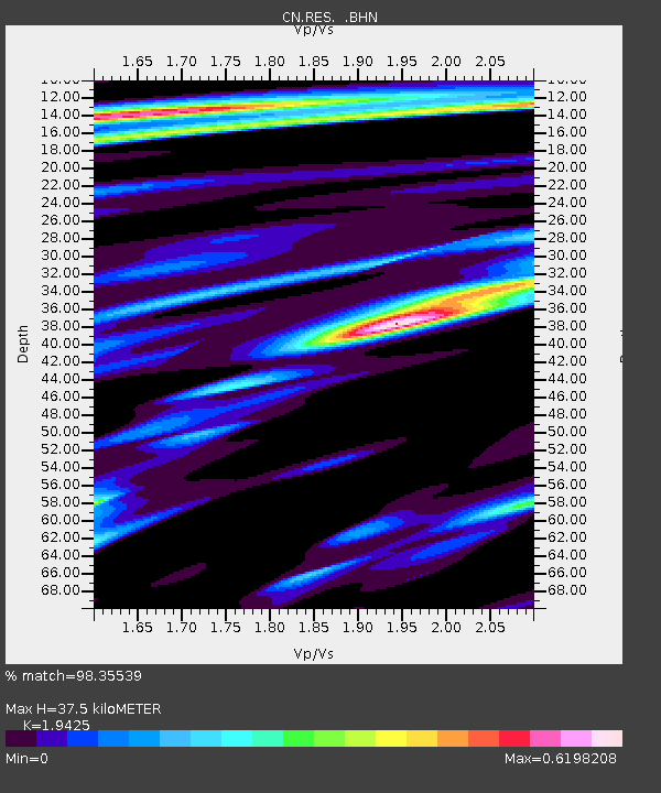
| Estimated Moho Depth: |
37.5 km |
| Estimated Crust Vp/Vs: |
1.94 |
| Assumed Crust Vp: |
6.367 km/s |
| Estimated Crust Vs: |
3.278 km/s |
| Estimated Crust Poisson's Ratio: |
0.32 |
|
| Radial Match: |
98.35539 % |
| Radial Bump: |
335 |
| Transverse Match: |
92.81278 % |
| Transverse Bump: |
400 |
| SOD ConfigId: |
319893 |
| Insert Time: |
2011-01-05 21:17:47.807 +0000 |
| GWidth: |
2.5 |
| Max Bumps: |
400 |
| Tol: |
0.001 |
|

Signal To Noise
| Channel | StoN | STA | LTA |
| CN:RES: :BHZ:20100813T21:31:43.85001Z | 11.204732 | 2.0680868E-6 | 1.8457263E-7 |
| CN:RES: :BHN:20100813T21:31:43.85001Z | 4.400187 | 4.5999946E-7 | 1.0454089E-7 |
| CN:RES: :BHE:20100813T21:31:43.85001Z | 4.26443 | 5.680713E-7 | 1.3321153E-7 |
| Arrivals |
| Ps | 5.7 SECOND |
| PpPs | 17 SECOND |
| PsPs/PpSs | 23 SECOND |


