You are here: Home > Network List > UW - Pacific Northwest Regional Seismic Network Stations List
> Station UMAT Pilot Rock, OR, USA > Earthquake Result Viewer
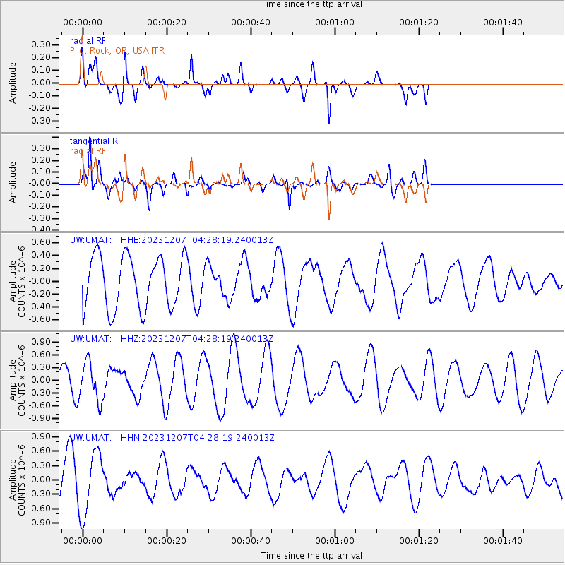
UMAT Pilot Rock, OR, USA - Earthquake Result Viewer
*The percent match for this event was below the threshold and hence no stack was calculated.
| Earthquake location: |
Caspian Sea |
| Earthquake latitude/longitude: |
41.2/49.7 |
| Earthquake time(UTC): |
2023/12/07 (341) 04:15:40 GMT |
| Earthquake Depth: |
42 km |
| Earthquake Magnitude: |
5.4 Mww |
| Earthquake Catalog/Contributor: |
NEIC PDE/us |
|
| Network: |
UW Pacific Northwest Regional Seismic Network |
| Station: |
UMAT Pilot Rock, OR, USA |
| Lat/Lon: |
45.29 N/118.96 W |
| Elevation: |
1318 m |
|
| Distance: |
93.3 deg |
| Az: |
352.037 deg |
| Baz: |
8.523 deg |
| Ray Param: |
$rayparam |
*The percent match for this event was below the threshold and hence was not used in the summary stack. |
|
| Radial Match: |
59.599052 % |
| Radial Bump: |
400 |
| Transverse Match: |
62.130604 % |
| Transverse Bump: |
335 |
| SOD ConfigId: |
33232451 |
| Insert Time: |
2023-12-21 04:52:09.712 +0000 |
| GWidth: |
2.5 |
| Max Bumps: |
400 |
| Tol: |
0.001 |
|
Signal To Noise
| Channel | StoN | STA | LTA |
| UW:UMAT: :HHZ:20231207T04:28:19.240013Z | 0.9317675 | 4.55539E-7 | 4.888977E-7 |
| UW:UMAT: :HHN:20231207T04:28:19.240013Z | 2.8118799 | 6.6015497E-7 | 2.3477354E-7 |
| UW:UMAT: :HHE:20231207T04:28:19.240013Z | 0.57335734 | 2.2983998E-7 | 4.008669E-7 |
| Arrivals |
| Ps | |
| PpPs | |
| PsPs/PpSs | |


