You are here: Home > Network List > CN - Canadian National Seismograph Network Stations List
> Station YKW3 > Earthquake Result Viewer
YKW3 - Earthquake Result Viewer
| Earthquake location: |
South Of Mariana Islands |
| Earthquake latitude/longitude: |
12.5/141.5 |
| Earthquake time(UTC): |
2010/08/13 (225) 21:19:33 GMT |
| Earthquake Depth: |
10 km |
| Earthquake Magnitude: |
6.5 MB, 6.9 MS, 6.9 MW, 6.9 MW |
| Earthquake Catalog/Contributor: |
WHDF/NEIC |
|
| Network: |
CN Canadian National Seismograph Network |
| Station: |
YKW3 |
| Lat/Lon: |
62.56 N/114.62 W |
| Elevation: |
200 m |
|
| Distance: |
85.3 deg |
| Az: |
26.819 deg |
| Baz: |
287.973 deg |
| Ray Param: |
0.04484961 |
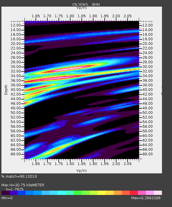
| Estimated Moho Depth: |
30.75 km |
| Estimated Crust Vp/Vs: |
1.79 |
| Assumed Crust Vp: |
6.459 km/s |
| Estimated Crust Vs: |
3.604 km/s |
| Estimated Crust Poisson's Ratio: |
0.27 |
|
| Radial Match: |
98.10018 % |
| Radial Bump: |
267 |
| Transverse Match: |
94.18216 % |
| Transverse Bump: |
400 |
| SOD ConfigId: |
319893 |
| Insert Time: |
2011-01-05 21:18:07.516 +0000 |
| GWidth: |
2.5 |
| Max Bumps: |
400 |
| Tol: |
0.001 |
|
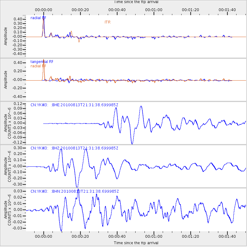
Signal To Noise
| Channel | StoN | STA | LTA |
| CN:YKW3: :BHZ:20100813T21:31:38.699985Z | 24.515318 | 3.364694E-8 | 1.3724863E-9 |
| CN:YKW3: :BHN:20100813T21:31:38.699985Z | 4.9873557 | 3.347956E-9 | 6.712888E-10 |
| CN:YKW3: :BHE:20100813T21:31:38.699985Z | 12.500848 | 1.15420224E-8 | 9.2329916E-10 |
| Arrivals |
| Ps | 3.9 SECOND |
| PpPs | 13 SECOND |
| PsPs/PpSs | 17 SECOND |


