You are here: Home > Network List > IU - Global Seismograph Network (GSN - IRIS/USGS) Stations List
> Station KNTN Kanton, Kiritibati > Earthquake Result Viewer
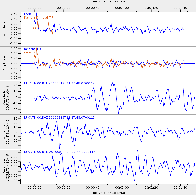
KNTN Kanton, Kiritibati - Earthquake Result Viewer

| Earthquake location: |
South Of Mariana Islands |
| Earthquake latitude/longitude: |
12.5/141.5 |
| Earthquake time(UTC): |
2010/08/13 (225) 21:19:33 GMT |
| Earthquake Depth: |
10 km |
| Earthquake Magnitude: |
6.5 MB, 6.9 MS, 6.9 MW, 6.9 MW |
| Earthquake Catalog/Contributor: |
WHDF/NEIC |
|
| Network: |
IU Global Seismograph Network (GSN - IRIS/USGS) |
| Station: |
KNTN Kanton, Kiritibati |
| Lat/Lon: |
2.77 S/171.72 W |
| Elevation: |
20 m |
|
| Distance: |
48.9 deg |
| Az: |
104.904 deg |
| Baz: |
289.109 deg |
| Ray Param: |
0.06905468 |
| Estimated Moho Depth: |
16.0 km |
| Estimated Crust Vp/Vs: |
1.60 |
| Assumed Crust Vp: |
4.24 km/s |
| Estimated Crust Vs: |
2.65 km/s |
| Estimated Crust Poisson's Ratio: |
0.18 |
|
| Radial Match: |
88.979675 % |
| Radial Bump: |
342 |
| Transverse Match: |
60.839066 % |
| Transverse Bump: |
392 |
| SOD ConfigId: |
319893 |
| Insert Time: |
2011-01-05 21:21:06.793 +0000 |
| GWidth: |
2.5 |
| Max Bumps: |
400 |
| Tol: |
0.001 |
|
Signal To Noise
| Channel | StoN | STA | LTA |
| IU:KNTN:00:BHZ:20100813T21:27:48.070011Z | 3.7563012 | 5.2174737E-6 | 1.3889924E-6 |
| IU:KNTN:00:BHN:20100813T21:27:48.070011Z | 0.4233468 | 1.1182925E-6 | 2.641552E-6 |
| IU:KNTN:00:BHE:20100813T21:27:48.070011Z | 0.8184371 | 1.6003934E-6 | 1.9554263E-6 |
| Arrivals |
| Ps | 2.3 SECOND |
| PpPs | 9.5 SECOND |
| PsPs/PpSs | 12 SECOND |


