You are here: Home > Network List > IU - Global Seismograph Network (GSN - IRIS/USGS) Stations List
> Station KIEV Kiev, Ukraine > Earthquake Result Viewer
KIEV Kiev, Ukraine - Earthquake Result Viewer
| Earthquake location: |
South Of Mariana Islands |
| Earthquake latitude/longitude: |
12.5/141.5 |
| Earthquake time(UTC): |
2010/08/13 (225) 21:19:33 GMT |
| Earthquake Depth: |
10 km |
| Earthquake Magnitude: |
6.5 MB, 6.9 MS, 6.9 MW, 6.9 MW |
| Earthquake Catalog/Contributor: |
WHDF/NEIC |
|
| Network: |
IU Global Seismograph Network (GSN - IRIS/USGS) |
| Station: |
KIEV Kiev, Ukraine |
| Lat/Lon: |
50.70 N/29.22 E |
| Elevation: |
180 m |
|
| Distance: |
94.0 deg |
| Az: |
323.845 deg |
| Baz: |
64.974 deg |
| Ray Param: |
0.041149642 |
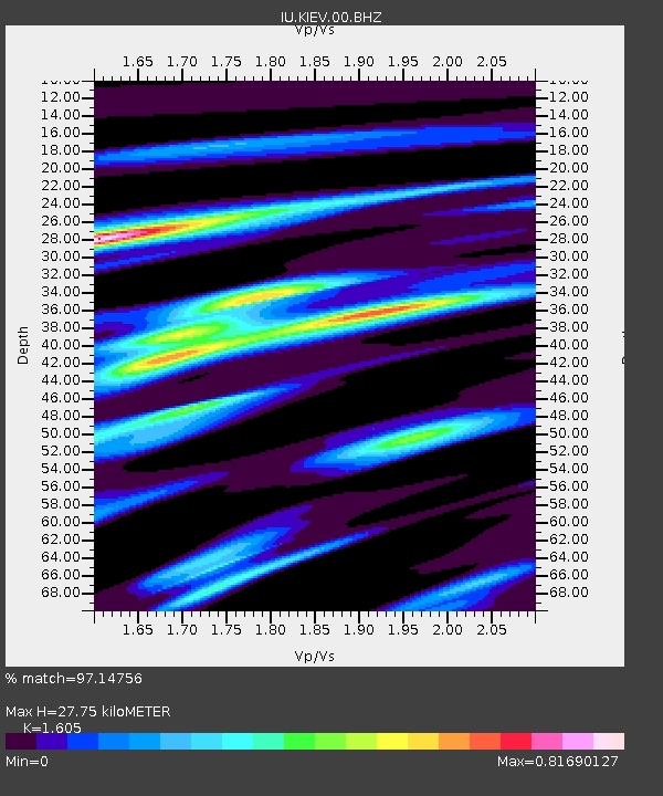
| Estimated Moho Depth: |
27.75 km |
| Estimated Crust Vp/Vs: |
1.61 |
| Assumed Crust Vp: |
6.552 km/s |
| Estimated Crust Vs: |
4.083 km/s |
| Estimated Crust Poisson's Ratio: |
0.18 |
|
| Radial Match: |
97.14756 % |
| Radial Bump: |
400 |
| Transverse Match: |
97.51857 % |
| Transverse Bump: |
342 |
| SOD ConfigId: |
319893 |
| Insert Time: |
2011-01-05 21:21:20.236 +0000 |
| GWidth: |
2.5 |
| Max Bumps: |
400 |
| Tol: |
0.001 |
|

Signal To Noise
| Channel | StoN | STA | LTA |
| IU:KIEV:00:BHZ:20100813T21:32:19.460972Z | 13.450514 | 5.7300116E-7 | 4.260069E-8 |
| IU:KIEV:00:BHN:20100813T21:32:19.460972Z | 3.340669 | 1.1589659E-7 | 3.469263E-8 |
| IU:KIEV:00:BHE:20100813T21:32:19.460972Z | 3.2295237 | 1.963583E-7 | 6.080101E-8 |
| Arrivals |
| Ps | 2.6 SECOND |
| PpPs | 11 SECOND |
| PsPs/PpSs | 13 SECOND |


