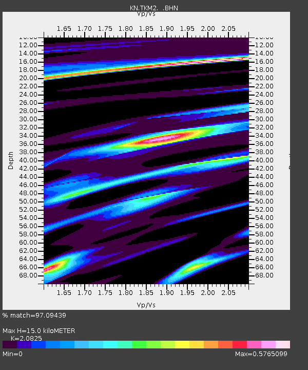
TKM2 KN.TKM2 - Earthquake Result Viewer
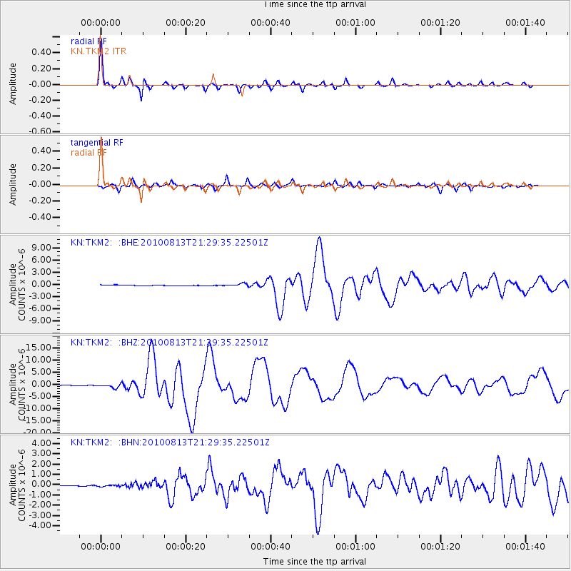
Earthquake location: South Of Mariana Islands
Earthquake latitude/longitude: 12.5/141.5
Earthquake time(UTC): 2010/08/13 (225) 21:19:33 GMT
Earthquake Depth: 10 km
Earthquake Magnitude: 6.5 MB, 6.9 MS, 6.9 MW, 6.9 MW
Earthquake Catalog/Contributor: WHDF/NEIC
Network: KN Kyrgyz Seismic Telemetry Network
Station: TKM2 KN.TKM2
Lat/Lon: 42.92 N/75.60 E
Elevation: 2020 m
Distance: 64.0 deg
Az: 311.742 deg
Baz: 97.227 deg
Ray Param: 0.059231635
Estimated Moho Depth: 15.0 km
Estimated Crust Vp/Vs: 2.08
Assumed Crust Vp: 6.306 km/s
Estimated Crust Vs: 3.028 km/s
Estimated Crust Poisson's Ratio: 0.35
Radial Match: 97.09439 %
Radial Bump: 274
Transverse Match: 85.17238 %
Transverse Bump: 400
SOD ConfigId: 319893
Insert Time: 2011-01-05 21:23:29.122 +0000
GWidth: 2.5
Max Bumps: 400
Tol: 0.001

Signal To Noise

ChannelStoNSTALTA
KN:TKM2: :BHZ:20100813T21:29:35.22501Z14.0257618.015872E-75.715107E-8
KN:TKM2: :BHN:20100813T21:29:35.22501Z1.03677746.353387E-86.128015E-8
KN:TKM2: :BHE:20100813T21:29:35.22501Z4.69550233.4063007E-77.2543905E-8
Arrivals
Ps2.7 SECOND
PpPs7.1 SECOND
PsPs/PpSs9.7 SECOND