You are here: Home > Network List > AK - Alaska Regional Network Stations List
> Station F20K Avaraart Lake, AK, USA > Earthquake Result Viewer
F20K Avaraart Lake, AK, USA - Earthquake Result Viewer
| Earthquake location: |
Vanuatu Islands |
| Earthquake latitude/longitude: |
-20.7/169.2 |
| Earthquake time(UTC): |
2023/12/07 (341) 12:56:30 GMT |
| Earthquake Depth: |
48 km |
| Earthquake Magnitude: |
7.1 Mww |
| Earthquake Catalog/Contributor: |
NEIC PDE/us |
|
| Network: |
AK Alaska Regional Network |
| Station: |
F20K Avaraart Lake, AK, USA |
| Lat/Lon: |
67.05 N/155.73 W |
| Elevation: |
136 m |
|
| Distance: |
91.3 deg |
| Az: |
13.025 deg |
| Baz: |
212.56 deg |
| Ray Param: |
0.041616097 |
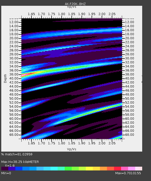
| Estimated Moho Depth: |
38.25 km |
| Estimated Crust Vp/Vs: |
1.60 |
| Assumed Crust Vp: |
6.522 km/s |
| Estimated Crust Vs: |
4.076 km/s |
| Estimated Crust Poisson's Ratio: |
0.18 |
|
| Radial Match: |
81.02959 % |
| Radial Bump: |
400 |
| Transverse Match: |
72.77663 % |
| Transverse Bump: |
400 |
| SOD ConfigId: |
33232451 |
| Insert Time: |
2023-12-21 13:01:05.342 +0000 |
| GWidth: |
2.5 |
| Max Bumps: |
400 |
| Tol: |
0.001 |
|

Signal To Noise
| Channel | StoN | STA | LTA |
| AK:F20K: :BHZ:20231207T13:08:59.579983Z | 9.932113 | 2.6330642E-6 | 2.6510617E-7 |
| AK:F20K: :BHN:20231207T13:08:59.579983Z | 3.826852 | 8.147392E-7 | 2.1290063E-7 |
| AK:F20K: :BHE:20231207T13:08:59.579983Z | 2.706914 | 5.717681E-7 | 2.1122509E-7 |
| Arrivals |
| Ps | 3.6 SECOND |
| PpPs | 15 SECOND |
| PsPs/PpSs | 18 SECOND |


