You are here: Home > Network List > AK - Alaska Regional Network Stations List
> Station L17K Donlin, AK, USA > Earthquake Result Viewer
L17K Donlin, AK, USA - Earthquake Result Viewer
| Earthquake location: |
Vanuatu Islands |
| Earthquake latitude/longitude: |
-20.7/169.2 |
| Earthquake time(UTC): |
2023/12/07 (341) 12:56:30 GMT |
| Earthquake Depth: |
48 km |
| Earthquake Magnitude: |
7.1 Mww |
| Earthquake Catalog/Contributor: |
NEIC PDE/us |
|
| Network: |
AK Alaska Regional Network |
| Station: |
L17K Donlin, AK, USA |
| Lat/Lon: |
62.13 N/158.30 W |
| Elevation: |
338 m |
|
| Distance: |
86.5 deg |
| Az: |
14.65 deg |
| Baz: |
210.27 deg |
| Ray Param: |
0.04394851 |
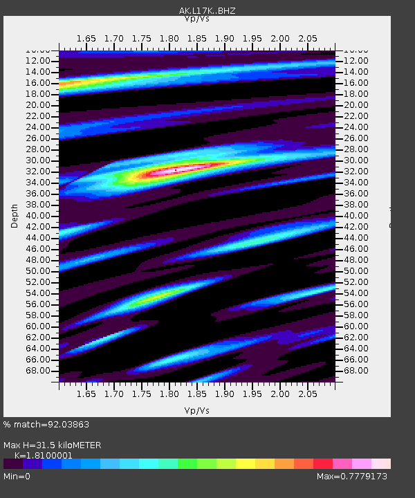
| Estimated Moho Depth: |
31.5 km |
| Estimated Crust Vp/Vs: |
1.81 |
| Assumed Crust Vp: |
6.276 km/s |
| Estimated Crust Vs: |
3.467 km/s |
| Estimated Crust Poisson's Ratio: |
0.28 |
|
| Radial Match: |
92.03863 % |
| Radial Bump: |
308 |
| Transverse Match: |
82.95399 % |
| Transverse Bump: |
400 |
| SOD ConfigId: |
33232451 |
| Insert Time: |
2023-12-21 13:03:14.083 +0000 |
| GWidth: |
2.5 |
| Max Bumps: |
400 |
| Tol: |
0.001 |
|

Signal To Noise
| Channel | StoN | STA | LTA |
| AK:L17K: :BHZ:20231207T13:08:37.019985Z | 15.077366 | 5.1524557E-6 | 3.4173448E-7 |
| AK:L17K: :BHN:20231207T13:08:37.019985Z | 6.724605 | 1.7100538E-6 | 2.5429804E-7 |
| AK:L17K: :BHE:20231207T13:08:37.019985Z | 5.253266 | 1.1599587E-6 | 2.2080717E-7 |
| Arrivals |
| Ps | 4.2 SECOND |
| PpPs | 14 SECOND |
| PsPs/PpSs | 18 SECOND |


