You are here: Home > Network List > AK - Alaska Regional Network Stations List
> Station N18K Kilae Creek, AK, USA > Earthquake Result Viewer
N18K Kilae Creek, AK, USA - Earthquake Result Viewer
| Earthquake location: |
Vanuatu Islands |
| Earthquake latitude/longitude: |
-20.7/169.2 |
| Earthquake time(UTC): |
2023/12/07 (341) 12:56:30 GMT |
| Earthquake Depth: |
48 km |
| Earthquake Magnitude: |
7.1 Mww |
| Earthquake Catalog/Contributor: |
NEIC PDE/us |
|
| Network: |
AK Alaska Regional Network |
| Station: |
N18K Kilae Creek, AK, USA |
| Lat/Lon: |
60.68 N/155.89 W |
| Elevation: |
572 m |
|
| Distance: |
85.8 deg |
| Az: |
16.402 deg |
| Baz: |
212.498 deg |
| Ray Param: |
0.044409126 |
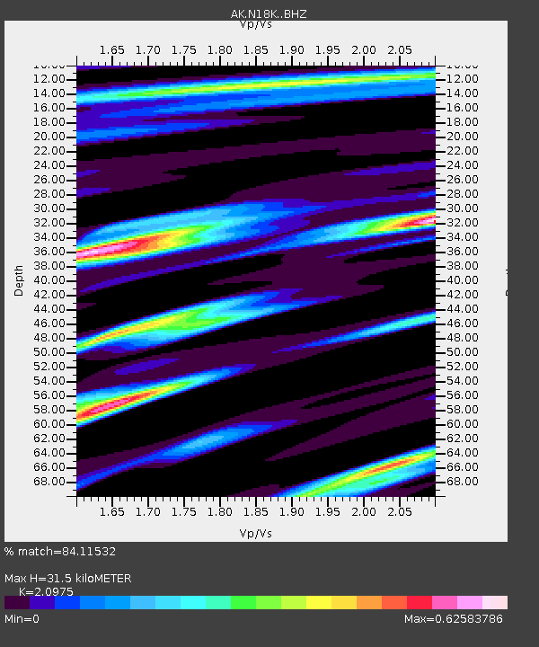
| Estimated Moho Depth: |
31.5 km |
| Estimated Crust Vp/Vs: |
2.10 |
| Assumed Crust Vp: |
6.566 km/s |
| Estimated Crust Vs: |
3.13 km/s |
| Estimated Crust Poisson's Ratio: |
0.35 |
|
| Radial Match: |
84.11532 % |
| Radial Bump: |
400 |
| Transverse Match: |
76.07896 % |
| Transverse Bump: |
400 |
| SOD ConfigId: |
33232451 |
| Insert Time: |
2023-12-21 13:04:03.926 +0000 |
| GWidth: |
2.5 |
| Max Bumps: |
400 |
| Tol: |
0.001 |
|

Signal To Noise
| Channel | StoN | STA | LTA |
| AK:N18K: :BHZ:20231207T13:08:33.879971Z | 17.875275 | 4.467551E-6 | 2.499291E-7 |
| AK:N18K: :BHN:20231207T13:08:33.879971Z | 5.341446 | 1.5763306E-6 | 2.951131E-7 |
| AK:N18K: :BHE:20231207T13:08:33.879971Z | 4.779834 | 1.0463156E-6 | 2.1890207E-7 |
| Arrivals |
| Ps | 5.4 SECOND |
| PpPs | 15 SECOND |
| PsPs/PpSs | 20 SECOND |


