You are here: Home > Network List > TA - USArray Transportable Network (new EarthScope stations) Stations List
> Station J22A Midwest, WY, USA > Earthquake Result Viewer
J22A Midwest, WY, USA - Earthquake Result Viewer

| Earthquake location: |
South Of Mariana Islands |
| Earthquake latitude/longitude: |
12.5/141.5 |
| Earthquake time(UTC): |
2010/08/13 (225) 21:19:33 GMT |
| Earthquake Depth: |
10 km |
| Earthquake Magnitude: |
6.5 MB, 6.9 MS, 6.9 MW, 6.9 MW |
| Earthquake Catalog/Contributor: |
WHDF/NEIC |
|
| Network: |
TA USArray Transportable Network (new EarthScope stations) |
| Station: |
J22A Midwest, WY, USA |
| Lat/Lon: |
43.41 N/106.48 W |
| Elevation: |
1587 m |
|
| Distance: |
96.9 deg |
| Az: |
42.872 deg |
| Baz: |
294.238 deg |
| Ray Param: |
0.040378015 |
| Estimated Moho Depth: |
50.0 km |
| Estimated Crust Vp/Vs: |
1.63 |
| Assumed Crust Vp: |
6.178 km/s |
| Estimated Crust Vs: |
3.79 km/s |
| Estimated Crust Poisson's Ratio: |
0.20 |
|
| Radial Match: |
92.49791 % |
| Radial Bump: |
400 |
| Transverse Match: |
87.40695 % |
| Transverse Bump: |
400 |
| SOD ConfigId: |
319893 |
| Insert Time: |
2011-01-05 21:26:57.731 +0000 |
| GWidth: |
2.5 |
| Max Bumps: |
400 |
| Tol: |
0.001 |
|
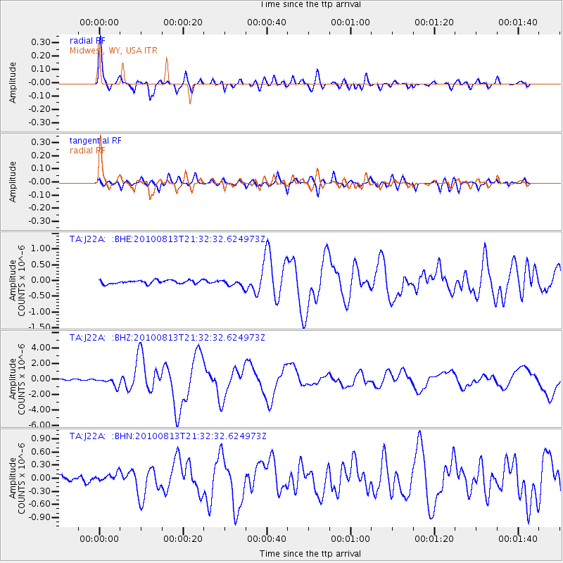
Signal To Noise
| Channel | StoN | STA | LTA |
| TA:J22A: :BHZ:20100813T21:32:32.624973Z | 8.220698 | 5.98757E-7 | 7.28353E-8 |
| TA:J22A: :BHN:20100813T21:32:32.624973Z | 1.448928 | 1.0064859E-7 | 6.946417E-8 |
| TA:J22A: :BHE:20100813T21:32:32.624973Z | 2.1237817 | 1.1588835E-7 | 5.456698E-8 |
| Arrivals |
| Ps | 5.2 SECOND |
| PpPs | 21 SECOND |
| PsPs/PpSs | 26 SECOND |


