You are here: Home > Network List > TA - USArray Transportable Network (new EarthScope stations) Stations List
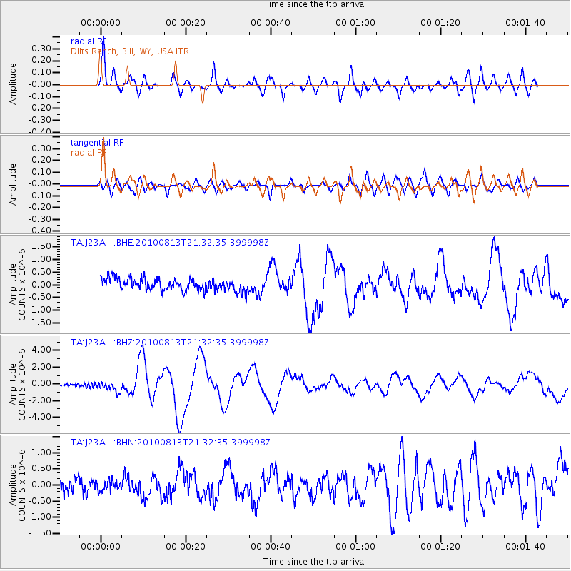
> Station J23A Dilts Ranch, Bill, WY, USA > Earthquake Result Viewer
J23A Dilts Ranch, Bill, WY, USA - Earthquake Result Viewer
| Earthquake location: |
South Of Mariana Islands |
| Earthquake latitude/longitude: |
12.5/141.5 |
| Earthquake time(UTC): |
2010/08/13 (225) 21:19:33 GMT |
| Earthquake Depth: |
10 km |
| Earthquake Magnitude: |
6.5 MB, 6.9 MS, 6.9 MW, 6.9 MW |
| Earthquake Catalog/Contributor: |
WHDF/NEIC |
|
| Network: |
TA USArray Transportable Network (new EarthScope stations) |
| Station: |
J23A Dilts Ranch, Bill, WY, USA |
| Lat/Lon: |
43.40 N/105.55 W |
| Elevation: |
1499 m |
|
| Distance: |
97.5 deg |
| Az: |
42.597 deg |
| Baz: |
294.907 deg |
| Ray Param: |
0.04019177 |
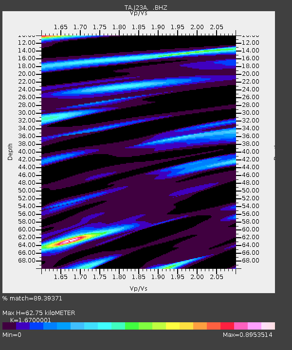
| Estimated Moho Depth: |
62.75 km |
| Estimated Crust Vp/Vs: |
1.67 |
| Assumed Crust Vp: |
6.159 km/s |
| Estimated Crust Vs: |
3.688 km/s |
| Estimated Crust Poisson's Ratio: |
0.22 |
|
| Radial Match: |
89.39371 % |
| Radial Bump: |
400 |
| Transverse Match: |
81.80085 % |
| Transverse Bump: |
400 |
| SOD ConfigId: |
319893 |
| Insert Time: |
2011-01-05 21:27:41.983 +0000 |
| GWidth: |
2.5 |
| Max Bumps: |
400 |
| Tol: |
0.001 |
|
Signal To Noise
| Channel | StoN | STA | LTA |
| TA:J23A: :BHZ:20100813T21:32:35.399998Z | 3.7383044 | 5.8368164E-7 | 1.561354E-7 |
| TA:J23A: :BHN:20100813T21:32:35.399998Z | 0.8046727 | 1.5418794E-7 | 1.9161573E-7 |
| TA:J23A: :BHE:20100813T21:32:35.399998Z | 1.3368989 | 3.0044836E-7 | 2.2473527E-7 |
| Arrivals |
| Ps | 7.0 SECOND |
| PpPs | 27 SECOND |
| PsPs/PpSs | 34 SECOND |


