You are here: Home > Network List > TA - USArray Transportable Network (new EarthScope stations) Stations List
> Station E26A Carlson Angus Ranch, Regent, ND, USA > Earthquake Result Viewer
E26A Carlson Angus Ranch, Regent, ND, USA - Earthquake Result Viewer
| Earthquake location: |
South Of Mariana Islands |
| Earthquake latitude/longitude: |
12.5/141.5 |
| Earthquake time(UTC): |
2010/08/13 (225) 21:19:33 GMT |
| Earthquake Depth: |
10 km |
| Earthquake Magnitude: |
6.5 MB, 6.9 MS, 6.9 MW, 6.9 MW |
| Earthquake Catalog/Contributor: |
WHDF/NEIC |
|
| Network: |
TA USArray Transportable Network (new EarthScope stations) |
| Station: |
E26A Carlson Angus Ranch, Regent, ND, USA |
| Lat/Lon: |
46.47 N/102.46 W |
| Elevation: |
806 m |
|
| Distance: |
98.1 deg |
| Az: |
38.841 deg |
| Baz: |
297.594 deg |
| Ray Param: |
0.040000875 |
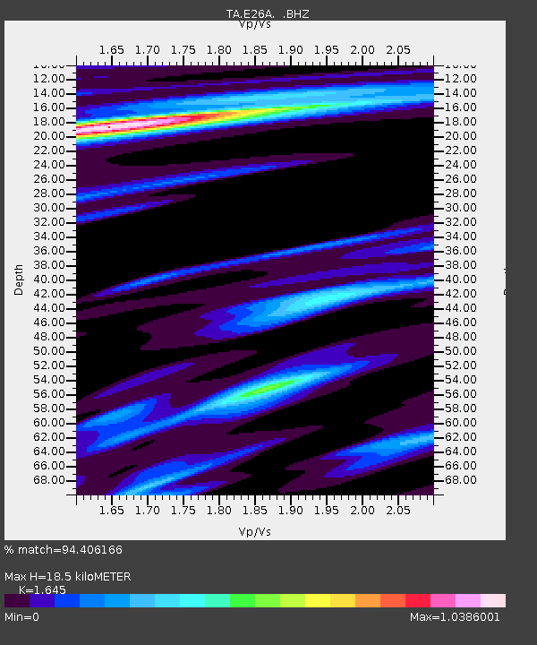
| Estimated Moho Depth: |
18.5 km |
| Estimated Crust Vp/Vs: |
1.64 |
| Assumed Crust Vp: |
6.402 km/s |
| Estimated Crust Vs: |
3.892 km/s |
| Estimated Crust Poisson's Ratio: |
0.21 |
|
| Radial Match: |
94.406166 % |
| Radial Bump: |
374 |
| Transverse Match: |
83.35155 % |
| Transverse Bump: |
400 |
| SOD ConfigId: |
319893 |
| Insert Time: |
2011-01-05 21:28:46.594 +0000 |
| GWidth: |
2.5 |
| Max Bumps: |
400 |
| Tol: |
0.001 |
|

Signal To Noise
| Channel | StoN | STA | LTA |
| TA:E26A: :BHZ:20100813T21:32:38.124973Z | 4.974182 | 7.1012494E-7 | 1.4276215E-7 |
| TA:E26A: :BHN:20100813T21:32:38.124973Z | 1.3136525 | 1.8748617E-7 | 1.4272126E-7 |
| TA:E26A: :BHE:20100813T21:32:38.124973Z | 0.86445177 | 1.6237263E-7 | 1.8783308E-7 |
| Arrivals |
| Ps | 1.9 SECOND |
| PpPs | 7.5 SECOND |
| PsPs/PpSs | 9.4 SECOND |


