You are here: Home > Network List > TA - USArray Transportable Network (new EarthScope stations) Stations List
> Station F25A Bowman, SD, USA > Earthquake Result Viewer
F25A Bowman, SD, USA - Earthquake Result Viewer
| Earthquake location: |
South Of Mariana Islands |
| Earthquake latitude/longitude: |
12.5/141.5 |
| Earthquake time(UTC): |
2010/08/13 (225) 21:19:33 GMT |
| Earthquake Depth: |
10 km |
| Earthquake Magnitude: |
6.5 MB, 6.9 MS, 6.9 MW, 6.9 MW |
| Earthquake Catalog/Contributor: |
WHDF/NEIC |
|
| Network: |
TA USArray Transportable Network (new EarthScope stations) |
| Station: |
F25A Bowman, SD, USA |
| Lat/Lon: |
45.93 N/103.46 W |
| Elevation: |
912 m |
|
| Distance: |
97.8 deg |
| Az: |
39.65 deg |
| Baz: |
296.766 deg |
| Ray Param: |
0.040117368 |
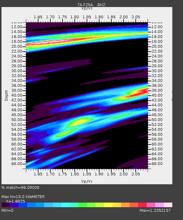
| Estimated Moho Depth: |
18.0 km |
| Estimated Crust Vp/Vs: |
1.69 |
| Assumed Crust Vp: |
6.242 km/s |
| Estimated Crust Vs: |
3.688 km/s |
| Estimated Crust Poisson's Ratio: |
0.23 |
|
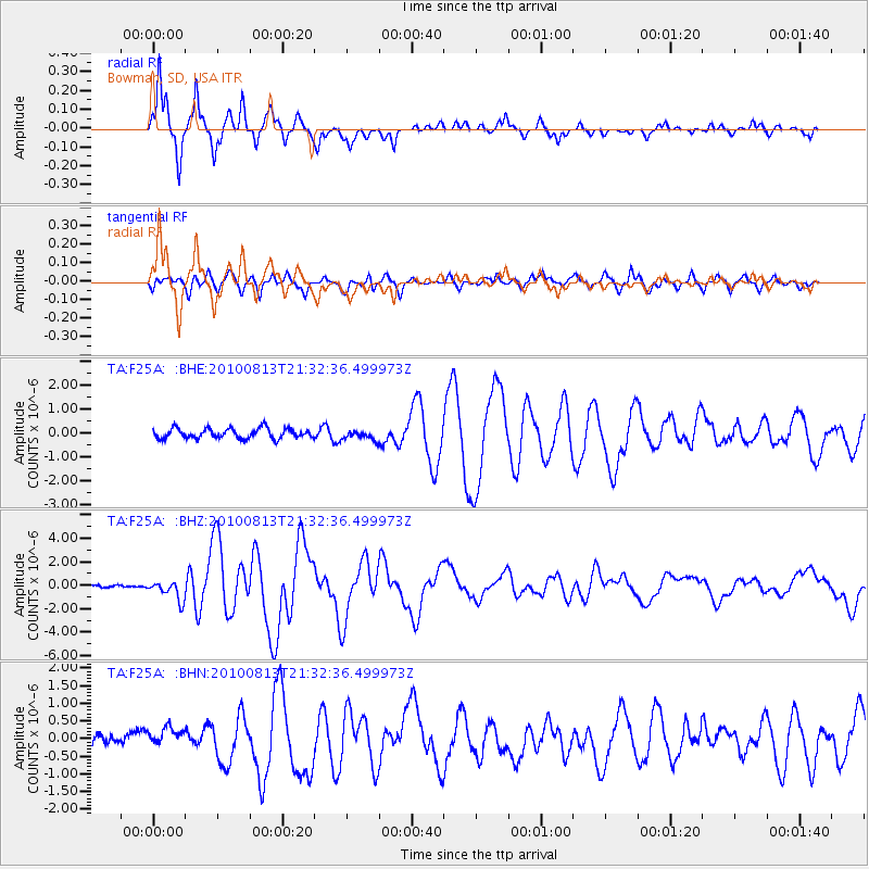
| Radial Match: |
96.09008 % |
| Radial Bump: |
400 |
| Transverse Match: |
85.063446 % |
| Transverse Bump: |
400 |
| SOD ConfigId: |
319893 |
| Insert Time: |
2011-01-05 21:28:52.870 +0000 |
| GWidth: |
2.5 |
| Max Bumps: |
400 |
| Tol: |
0.001 |
|
Signal To Noise
| Channel | StoN | STA | LTA |
| TA:F25A: :BHZ:20100813T21:32:36.499973Z | 7.836794 | 8.253475E-7 | 1.05316985E-7 |
| TA:F25A: :BHN:20100813T21:32:36.499973Z | 1.7352308 | 3.1595366E-7 | 1.8208164E-7 |
| TA:F25A: :BHE:20100813T21:32:36.499973Z | 0.9647014 | 1.9859706E-7 | 2.0586376E-7 |
| Arrivals |
| Ps | 2.0 SECOND |
| PpPs | 7.6 SECOND |
| PsPs/PpSs | 9.7 SECOND |


