You are here: Home > Network List > TA - USArray Transportable Network (new EarthScope stations) Stations List
> Station B25A Knox Farm, Ray, ND, USA > Earthquake Result Viewer
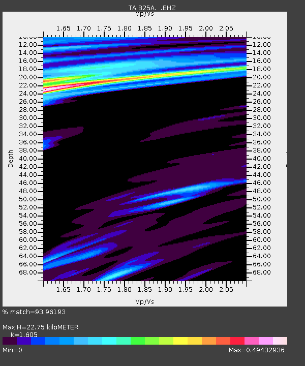
B25A Knox Farm, Ray, ND, USA - Earthquake Result Viewer
| Earthquake location: |
South Of Mariana Islands |
| Earthquake latitude/longitude: |
12.5/141.5 |
| Earthquake time(UTC): |
2010/08/13 (225) 21:19:33 GMT |
| Earthquake Depth: |
10 km |
| Earthquake Magnitude: |
6.5 MB, 6.9 MS, 6.9 MW, 6.9 MW |
| Earthquake Catalog/Contributor: |
WHDF/NEIC |
|
| Network: |
TA USArray Transportable Network (new EarthScope stations) |
| Station: |
B25A Knox Farm, Ray, ND, USA |
| Lat/Lon: |
48.27 N/103.16 W |
| Elevation: |
705 m |
|
| Distance: |
96.9 deg |
| Az: |
37.45 deg |
| Baz: |
297.263 deg |
| Ray Param: |
0.040384535 |
| Estimated Moho Depth: |
22.75 km |
| Estimated Crust Vp/Vs: |
1.61 |
| Assumed Crust Vp: |
6.438 km/s |
| Estimated Crust Vs: |
4.011 km/s |
| Estimated Crust Poisson's Ratio: |
0.18 |
|
| Radial Match: |
93.96193 % |
| Radial Bump: |
400 |
| Transverse Match: |
82.633545 % |
| Transverse Bump: |
400 |
| SOD ConfigId: |
319893 |
| Insert Time: |
2011-01-05 21:29:20.818 +0000 |
| GWidth: |
2.5 |
| Max Bumps: |
400 |
| Tol: |
0.001 |
|

Signal To Noise
| Channel | StoN | STA | LTA |
| TA:B25A: :BHZ:20100813T21:32:32.550022Z | 4.892618 | 7.524641E-7 | 1.5379578E-7 |
| TA:B25A: :BHN:20100813T21:32:32.550022Z | 0.75033766 | 1.9975914E-7 | 2.6622567E-7 |
| TA:B25A: :BHE:20100813T21:32:32.550022Z | 0.68796605 | 2.0224098E-7 | 2.9396944E-7 |
| Arrivals |
| Ps | 2.2 SECOND |
| PpPs | 9.0 SECOND |
| PsPs/PpSs | 11 SECOND |


