You are here: Home > Network List > TA - USArray Transportable Network (new EarthScope stations) Stations List
> Station G03D McMinnville, OR, USA > Earthquake Result Viewer
G03D McMinnville, OR, USA - Earthquake Result Viewer
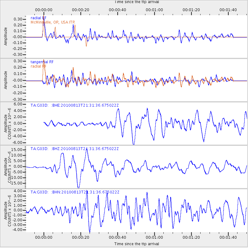
| Earthquake location: |
South Of Mariana Islands |
| Earthquake latitude/longitude: |
12.5/141.5 |
| Earthquake time(UTC): |
2010/08/13 (225) 21:19:33 GMT |
| Earthquake Depth: |
10 km |
| Earthquake Magnitude: |
6.5 MB, 6.9 MS, 6.9 MW, 6.9 MW |
| Earthquake Catalog/Contributor: |
WHDF/NEIC |
|
| Network: |
TA USArray Transportable Network (new EarthScope stations) |
| Station: |
G03D McMinnville, OR, USA |
| Lat/Lon: |
45.21 N/123.26 W |
| Elevation: |
222 m |
|
| Distance: |
84.9 deg |
| Az: |
44.965 deg |
| Baz: |
282.475 deg |
| Ray Param: |
0.045140445 |
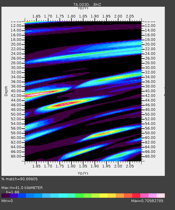
| Estimated Moho Depth: |
41.0 km |
| Estimated Crust Vp/Vs: |
1.66 |
| Assumed Crust Vp: |
6.566 km/s |
| Estimated Crust Vs: |
3.956 km/s |
| Estimated Crust Poisson's Ratio: |
0.22 |
|
| Radial Match: |
90.89605 % |
| Radial Bump: |
400 |
| Transverse Match: |
83.61848 % |
| Transverse Bump: |
400 |
| SOD ConfigId: |
319893 |
| Insert Time: |
2011-01-05 21:30:23.153 +0000 |
| GWidth: |
2.5 |
| Max Bumps: |
400 |
| Tol: |
0.001 |
|
Signal To Noise
| Channel | StoN | STA | LTA |
| TA:G03D: :BHZ:20100813T21:31:36.675022Z | 4.7209444 | 1.4868257E-6 | 3.1494244E-7 |
| TA:G03D: :BHN:20100813T21:31:36.675022Z | 0.7549912 | 3.6435094E-7 | 4.8258966E-7 |
| TA:G03D: :BHE:20100813T21:31:36.675022Z | 1.1933855 | 4.7930894E-7 | 4.01638E-7 |
| Arrivals |
| Ps | 4.2 SECOND |
| PpPs | 16 SECOND |
| PsPs/PpSs | 20 SECOND |


