You are here: Home > Network List > AV - Alaska Volcano Observatory Stations List
> Station MAPS Pakushin Southeast, Makushin Volcano, Alaska > Earthquake Result Viewer
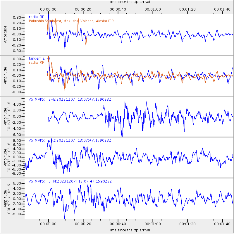
MAPS Pakushin Southeast, Makushin Volcano, Alaska - Earthquake Result Viewer
*The percent match for this event was below the threshold and hence no stack was calculated.
| Earthquake location: |
Vanuatu Islands |
| Earthquake latitude/longitude: |
-20.7/169.2 |
| Earthquake time(UTC): |
2023/12/07 (341) 12:56:30 GMT |
| Earthquake Depth: |
48 km |
| Earthquake Magnitude: |
7.1 Mww |
| Earthquake Catalog/Contributor: |
NEIC PDE/us |
|
| Network: |
AV Alaska Volcano Observatory |
| Station: |
MAPS Pakushin Southeast, Makushin Volcano, Alaska |
| Lat/Lon: |
53.81 N/166.94 W |
| Elevation: |
333 m |
|
| Distance: |
77.0 deg |
| Az: |
14.251 deg |
| Baz: |
202.875 deg |
| Ray Param: |
$rayparam |
*The percent match for this event was below the threshold and hence was not used in the summary stack. |
|
| Radial Match: |
44.179176 % |
| Radial Bump: |
400 |
| Transverse Match: |
41.43398 % |
| Transverse Bump: |
400 |
| SOD ConfigId: |
33232451 |
| Insert Time: |
2023-12-21 15:47:36.241 +0000 |
| GWidth: |
2.5 |
| Max Bumps: |
400 |
| Tol: |
0.001 |
|
Signal To Noise
| Channel | StoN | STA | LTA |
| AV:MAPS: :BHZ:20231207T13:07:47.159023Z | 2.8330898 | 5.1415122E-6 | 1.8148072E-6 |
| AV:MAPS: :BHN:20231207T13:07:47.159023Z | 1.687498 | 2.5521367E-6 | 1.5123792E-6 |
| AV:MAPS: :BHE:20231207T13:07:47.159023Z | 1.770816 | 1.7011673E-6 | 9.606686E-7 |
| Arrivals |
| Ps | |
| PpPs | |
| PsPs/PpSs | |


