You are here: Home > Network List > US - United States National Seismic Network Stations List
> Station MVCO Mesa Verde, Colorado, USA > Earthquake Result Viewer
MVCO Mesa Verde, Colorado, USA - Earthquake Result Viewer
| Earthquake location: |
South Of Mariana Islands |
| Earthquake latitude/longitude: |
12.5/141.5 |
| Earthquake time(UTC): |
2010/08/13 (225) 21:19:33 GMT |
| Earthquake Depth: |
10 km |
| Earthquake Magnitude: |
6.5 MB, 6.9 MS, 6.9 MW, 6.9 MW |
| Earthquake Catalog/Contributor: |
WHDF/NEIC |
|
| Network: |
US United States National Seismic Network |
| Station: |
MVCO Mesa Verde, Colorado, USA |
| Lat/Lon: |
37.21 N/108.50 W |
| Elevation: |
2170 m |
|
| Distance: |
97.9 deg |
| Az: |
49.228 deg |
| Baz: |
292.114 deg |
| Ray Param: |
0.04006833 |
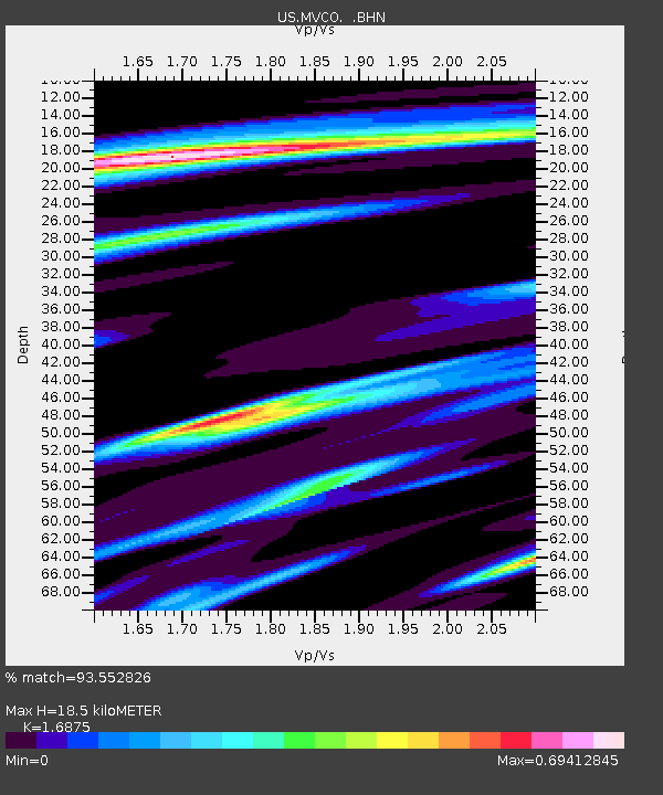
| Estimated Moho Depth: |
18.5 km |
| Estimated Crust Vp/Vs: |
1.69 |
| Assumed Crust Vp: |
6.476 km/s |
| Estimated Crust Vs: |
3.838 km/s |
| Estimated Crust Poisson's Ratio: |
0.23 |
|
| Radial Match: |
93.552826 % |
| Radial Bump: |
400 |
| Transverse Match: |
88.78267 % |
| Transverse Bump: |
400 |
| SOD ConfigId: |
319893 |
| Insert Time: |
2011-01-05 21:33:40.576 +0000 |
| GWidth: |
2.5 |
| Max Bumps: |
400 |
| Tol: |
0.001 |
|

Signal To Noise
| Channel | StoN | STA | LTA |
| US:MVCO: :BHZ:20100813T21:32:37.175022Z | 4.343669 | 3.5249835E-7 | 8.1152216E-8 |
| US:MVCO: :BHN:20100813T21:32:37.175022Z | 0.9830458 | 6.756187E-8 | 6.872708E-8 |
| US:MVCO: :BHE:20100813T21:32:37.175022Z | 0.93444407 | 1.05419055E-7 | 1.1281473E-7 |
| Arrivals |
| Ps | 2.0 SECOND |
| PpPs | 7.5 SECOND |
| PsPs/PpSs | 9.5 SECOND |


