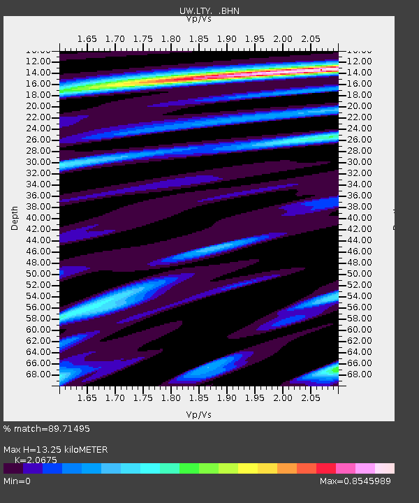
LTY Liberty (broad-band) - Earthquake Result Viewer

Earthquake location: South Of Mariana Islands
Earthquake latitude/longitude: 12.5/141.5
Earthquake time(UTC): 2010/08/13 (225) 21:19:33 GMT
Earthquake Depth: 10 km
Earthquake Magnitude: 6.5 MB, 6.9 MS, 6.9 MW, 6.9 MW
Earthquake Catalog/Contributor: WHDF/NEIC
Network: UW Pacific Northwest Regional Seismic Network
Station: LTY Liberty (broad-band)
Lat/Lon: 47.26 N/120.66 W
Elevation: 970 m
Distance: 86.2 deg
Az: 42.553 deg
Baz: 284.159 deg
Ray Param: 0.044221073
Estimated Moho Depth: 13.25 km
Estimated Crust Vp/Vs: 2.07
Assumed Crust Vp: 6.597 km/s
Estimated Crust Vs: 3.191 km/s
Estimated Crust Poisson's Ratio: 0.35
Radial Match: 89.71495 %
Radial Bump: 389
Transverse Match: 92.582 %
Transverse Bump: 362
SOD ConfigId: 319893
Insert Time: 2011-01-05 21:34:03.019 +0000
GWidth: 2.5
Max Bumps: 400
Tol: 0.001

Signal To Noise

ChannelStoNSTALTA
UW:LTY: :BHZ:20100813T21:31:43.037998Z25.568031.3947665E-65.455119E-8
UW:LTY: :BHN:20100813T21:31:43.037998Z1.58056651.9176375E-71.2132595E-7
UW:LTY: :BHE:20100813T21:31:43.037998Z4.8753414.120329E-78.451366E-8
Arrivals
Ps2.2 SECOND
PpPs6.0 SECOND
PsPs/PpSs8.2 SECOND