You are here: Home > Network List > UW - Pacific Northwest Regional Seismic Network Stations List
> Station DAVN Chrisman Ranch, Davenport, WA, USA > Earthquake Result Viewer
DAVN Chrisman Ranch, Davenport, WA, USA - Earthquake Result Viewer

| Earthquake location: |
South Of Mariana Islands |
| Earthquake latitude/longitude: |
12.5/141.5 |
| Earthquake time(UTC): |
2010/08/13 (225) 21:19:33 GMT |
| Earthquake Depth: |
10 km |
| Earthquake Magnitude: |
6.5 MB, 6.9 MS, 6.9 MW, 6.9 MW |
| Earthquake Catalog/Contributor: |
WHDF/NEIC |
|
| Network: |
UW Pacific Northwest Regional Seismic Network |
| Station: |
DAVN Chrisman Ranch, Davenport, WA, USA |
| Lat/Lon: |
47.80 N/118.27 W |
| Elevation: |
495 m |
|
| Distance: |
87.6 deg |
| Az: |
41.605 deg |
| Baz: |
285.866 deg |
| Ray Param: |
0.043192133 |
| Estimated Moho Depth: |
30.5 km |
| Estimated Crust Vp/Vs: |
1.67 |
| Assumed Crust Vp: |
6.419 km/s |
| Estimated Crust Vs: |
3.85 km/s |
| Estimated Crust Poisson's Ratio: |
0.22 |
|
| Radial Match: |
94.652695 % |
| Radial Bump: |
296 |
| Transverse Match: |
82.477615 % |
| Transverse Bump: |
400 |
| SOD ConfigId: |
319893 |
| Insert Time: |
2011-01-05 21:35:36.648 +0000 |
| GWidth: |
2.5 |
| Max Bumps: |
400 |
| Tol: |
0.001 |
|
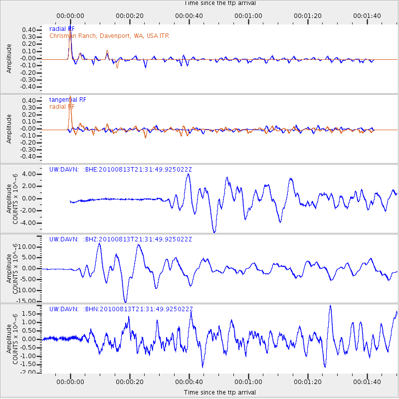
Signal To Noise
| Channel | StoN | STA | LTA |
| UW:DAVN: :BHZ:20100813T21:31:49.925022Z | 22.29359 | 1.3961452E-6 | 6.262541E-8 |
| UW:DAVN: :BHN:20100813T21:31:49.925022Z | 1.6884217 | 1.6820559E-7 | 9.9622966E-8 |
| UW:DAVN: :BHE:20100813T21:31:49.925022Z | 3.1316905 | 5.068653E-7 | 1.6185038E-7 |
| Arrivals |
| Ps | 3.2 SECOND |
| PpPs | 12 SECOND |
| PsPs/PpSs | 16 SECOND |


