You are here: Home > Network List > UO - University of Oregon Regional Network Stations List
> Station TOOM Fort Rock, OR, USA > Earthquake Result Viewer
TOOM Fort Rock, OR, USA - Earthquake Result Viewer
| Earthquake location: |
Vanuatu Islands |
| Earthquake latitude/longitude: |
-20.7/169.2 |
| Earthquake time(UTC): |
2023/12/07 (341) 12:56:30 GMT |
| Earthquake Depth: |
48 km |
| Earthquake Magnitude: |
7.1 Mww |
| Earthquake Catalog/Contributor: |
NEIC PDE/us |
|
| Network: |
UO University of Oregon Regional Network |
| Station: |
TOOM Fort Rock, OR, USA |
| Lat/Lon: |
43.28 N/121.23 W |
| Elevation: |
1541 m |
|
| Distance: |
90.0 deg |
| Az: |
43.178 deg |
| Baz: |
241.343 deg |
| Ray Param: |
0.041720085 |
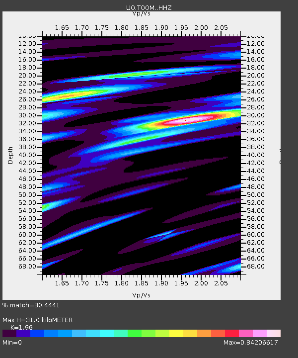
| Estimated Moho Depth: |
31.0 km |
| Estimated Crust Vp/Vs: |
1.96 |
| Assumed Crust Vp: |
6.597 km/s |
| Estimated Crust Vs: |
3.366 km/s |
| Estimated Crust Poisson's Ratio: |
0.32 |
|
| Radial Match: |
80.4441 % |
| Radial Bump: |
376 |
| Transverse Match: |
65.558266 % |
| Transverse Bump: |
400 |
| SOD ConfigId: |
33232451 |
| Insert Time: |
2023-12-21 16:04:32.135 +0000 |
| GWidth: |
2.5 |
| Max Bumps: |
400 |
| Tol: |
0.001 |
|

Signal To Noise
| Channel | StoN | STA | LTA |
| UO:TOOM: :HHZ:20231207T13:08:53.940029Z | 8.524495 | 4.631487E-6 | 5.4331514E-7 |
| UO:TOOM: :HHN:20231207T13:08:53.940029Z | 1.8403745 | 1.6238902E-6 | 8.823694E-7 |
| UO:TOOM: :HHE:20231207T13:08:53.940029Z | 0.9293673 | 9.0545103E-7 | 9.742661E-7 |
| Arrivals |
| Ps | 4.6 SECOND |
| PpPs | 14 SECOND |
| PsPs/PpSs | 18 SECOND |


