You are here: Home > Network List > CI - Caltech Regional Seismic Network Stations List
> Station BAR Barrett, Tecate, CA, USA > Earthquake Result Viewer
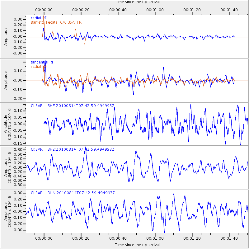
BAR Barrett, Tecate, CA, USA - Earthquake Result Viewer
*The percent match for this event was below the threshold and hence no stack was calculated.
| Earthquake location: |
South Of Mariana Islands |
| Earthquake latitude/longitude: |
12.3/141.5 |
| Earthquake time(UTC): |
2010/08/14 (226) 07:30:16 GMT |
| Earthquake Depth: |
10 km |
| Earthquake Magnitude: |
6.0 MB, 6.0 MS, 6.2 MW, 6.1 MW |
| Earthquake Catalog/Contributor: |
WHDF/NEIC |
|
| Network: |
CI Caltech Regional Seismic Network |
| Station: |
BAR Barrett, Tecate, CA, USA |
| Lat/Lon: |
32.68 N/116.67 W |
| Elevation: |
521 m |
|
| Distance: |
93.1 deg |
| Az: |
55.755 deg |
| Baz: |
286.701 deg |
| Ray Param: |
$rayparam |
*The percent match for this event was below the threshold and hence was not used in the summary stack. |
|
| Radial Match: |
73.32249 % |
| Radial Bump: |
400 |
| Transverse Match: |
73.96496 % |
| Transverse Bump: |
400 |
| SOD ConfigId: |
319893 |
| Insert Time: |
2011-01-05 21:43:45.690 +0000 |
| GWidth: |
2.5 |
| Max Bumps: |
400 |
| Tol: |
0.001 |
|
Signal To Noise
| Channel | StoN | STA | LTA |
| CI:BAR: :BHZ:20100814T07:42:59.494993Z | 4.244798 | 3.3780347E-7 | 7.958057E-8 |
| CI:BAR: :BHN:20100814T07:42:59.494993Z | 1.7832358 | 9.82821E-8 | 5.5114473E-8 |
| CI:BAR: :BHE:20100814T07:42:59.494993Z | 1.9096112 | 6.0846766E-8 | 3.1863433E-8 |
| Arrivals |
| Ps | |
| PpPs | |
| PsPs/PpSs | |


