You are here: Home > Network List > UW - Pacific Northwest Regional Seismic Network Stations List
> Station HSR South Ridge, Mt. St. Helens, WA, USA > Earthquake Result Viewer
HSR South Ridge, Mt. St. Helens, WA, USA - Earthquake Result Viewer
| Earthquake location: |
Vanuatu Islands |
| Earthquake latitude/longitude: |
-20.7/169.2 |
| Earthquake time(UTC): |
2023/12/07 (341) 12:56:30 GMT |
| Earthquake Depth: |
48 km |
| Earthquake Magnitude: |
7.1 Mww |
| Earthquake Catalog/Contributor: |
NEIC PDE/us |
|
| Network: |
UW Pacific Northwest Regional Seismic Network |
| Station: |
HSR South Ridge, Mt. St. Helens, WA, USA |
| Lat/Lon: |
46.17 N/122.18 W |
| Elevation: |
1720 m |
|
| Distance: |
90.9 deg |
| Az: |
40.324 deg |
| Baz: |
240.702 deg |
| Ray Param: |
0.041660883 |
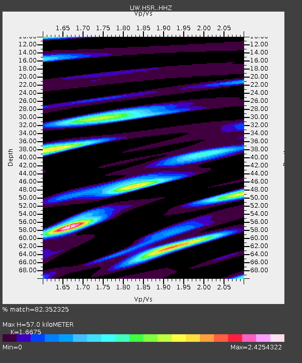
| Estimated Moho Depth: |
57.0 km |
| Estimated Crust Vp/Vs: |
1.67 |
| Assumed Crust Vp: |
6.566 km/s |
| Estimated Crust Vs: |
3.938 km/s |
| Estimated Crust Poisson's Ratio: |
0.22 |
|
| Radial Match: |
82.352325 % |
| Radial Bump: |
400 |
| Transverse Match: |
78.16892 % |
| Transverse Bump: |
400 |
| SOD ConfigId: |
33232451 |
| Insert Time: |
2023-12-21 16:07:46.530 +0000 |
| GWidth: |
2.5 |
| Max Bumps: |
400 |
| Tol: |
0.001 |
|

Signal To Noise
| Channel | StoN | STA | LTA |
| UW:HSR: :HHZ:20231207T13:08:57.690029Z | 6.860003 | 4.156828E-6 | 6.059513E-7 |
| UW:HSR: :HHN:20231207T13:08:57.690029Z | 1.5832092 | 1.664782E-6 | 1.0515237E-6 |
| UW:HSR: :HHE:20231207T13:08:57.690029Z | 2.2020326 | 1.579032E-6 | 7.170793E-7 |
| Arrivals |
| Ps | 5.9 SECOND |
| PpPs | 23 SECOND |
| PsPs/PpSs | 29 SECOND |


