You are here: Home > Network List > CI - Caltech Regional Seismic Network Stations List
> Station SLA SLA, Trona, CA, USA > Earthquake Result Viewer
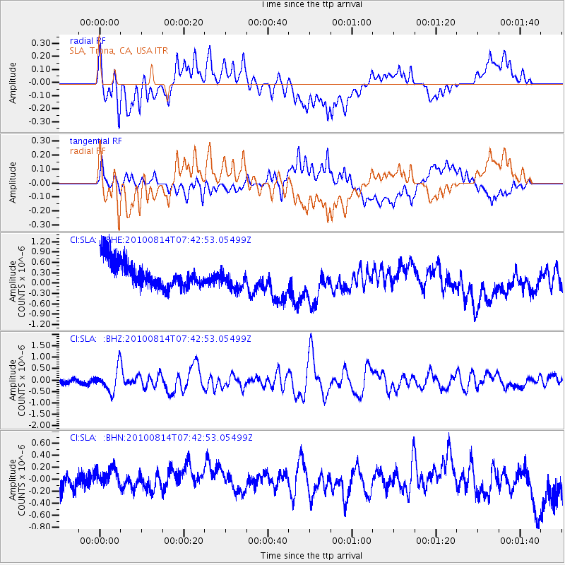
SLA SLA, Trona, CA, USA - Earthquake Result Viewer
*The percent match for this event was below the threshold and hence no stack was calculated.
| Earthquake location: |
South Of Mariana Islands |
| Earthquake latitude/longitude: |
12.3/141.5 |
| Earthquake time(UTC): |
2010/08/14 (226) 07:30:16 GMT |
| Earthquake Depth: |
10 km |
| Earthquake Magnitude: |
6.0 MB, 6.0 MS, 6.2 MW, 6.1 MW |
| Earthquake Catalog/Contributor: |
WHDF/NEIC |
|
| Network: |
CI Caltech Regional Seismic Network |
| Station: |
SLA SLA, Trona, CA, USA |
| Lat/Lon: |
35.89 N/117.28 W |
| Elevation: |
1174 m |
|
| Distance: |
91.7 deg |
| Az: |
52.828 deg |
| Baz: |
286.483 deg |
| Ray Param: |
$rayparam |
*The percent match for this event was below the threshold and hence was not used in the summary stack. |
|
| Radial Match: |
43.05533 % |
| Radial Bump: |
400 |
| Transverse Match: |
57.183186 % |
| Transverse Bump: |
400 |
| SOD ConfigId: |
319893 |
| Insert Time: |
2011-01-05 21:45:43.057 +0000 |
| GWidth: |
2.5 |
| Max Bumps: |
400 |
| Tol: |
0.001 |
|
Signal To Noise
| Channel | StoN | STA | LTA |
| CI:SLA: :BHZ:20100814T07:42:53.05499Z | 4.9868917 | 5.2298174E-7 | 1.0487128E-7 |
| CI:SLA: :BHN:20100814T07:42:53.05499Z | 1.6263057 | 2.1061918E-7 | 1.2950774E-7 |
| CI:SLA: :BHE:20100814T07:42:53.05499Z | 0.81500363 | 3.1871247E-7 | 3.9105652E-7 |
| Arrivals |
| Ps | |
| PpPs | |
| PsPs/PpSs | |


