You are here: Home > Network List > CI - Caltech Regional Seismic Network Stations List
> Station VES Vestal, Richgrove, CA, USA > Earthquake Result Viewer
VES Vestal, Richgrove, CA, USA - Earthquake Result Viewer
| Earthquake location: |
South Of Mariana Islands |
| Earthquake latitude/longitude: |
12.3/141.5 |
| Earthquake time(UTC): |
2010/08/14 (226) 07:30:16 GMT |
| Earthquake Depth: |
10 km |
| Earthquake Magnitude: |
6.0 MB, 6.0 MS, 6.2 MW, 6.1 MW |
| Earthquake Catalog/Contributor: |
WHDF/NEIC |
|
| Network: |
CI Caltech Regional Seismic Network |
| Station: |
VES Vestal, Richgrove, CA, USA |
| Lat/Lon: |
35.84 N/119.08 W |
| Elevation: |
154 m |
|
| Distance: |
90.4 deg |
| Az: |
53.278 deg |
| Baz: |
285.424 deg |
| Ray Param: |
0.041679304 |
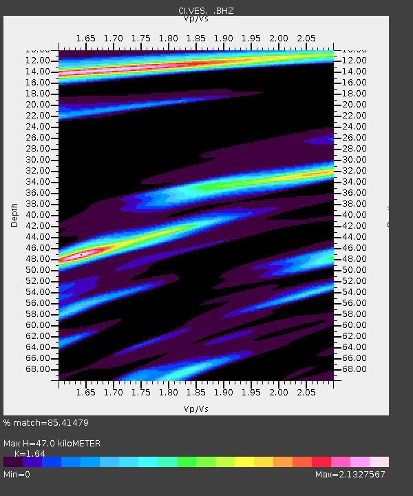
| Estimated Moho Depth: |
47.0 km |
| Estimated Crust Vp/Vs: |
1.64 |
| Assumed Crust Vp: |
6.1 km/s |
| Estimated Crust Vs: |
3.72 km/s |
| Estimated Crust Poisson's Ratio: |
0.20 |
|
| Radial Match: |
85.41479 % |
| Radial Bump: |
317 |
| Transverse Match: |
72.44814 % |
| Transverse Bump: |
360 |
| SOD ConfigId: |
319893 |
| Insert Time: |
2011-01-05 21:45:58.827 +0000 |
| GWidth: |
2.5 |
| Max Bumps: |
400 |
| Tol: |
0.001 |
|

Signal To Noise
| Channel | StoN | STA | LTA |
| CI:VES: :BHZ:20100814T07:42:46.606016Z | 7.715848 | 5.827194E-7 | 7.552241E-8 |
| CI:VES: :BHN:20100814T07:42:46.604978Z | 1.3785981 | 2.9992708E-7 | 2.1755947E-7 |
| CI:VES: :BHE:20100814T07:42:46.604978Z | 2.7229934 | 6.021533E-7 | 2.2113653E-7 |
| Arrivals |
| Ps | 5.0 SECOND |
| PpPs | 20 SECOND |
| PsPs/PpSs | 25 SECOND |


