You are here: Home > Network List > CI - Caltech Regional Seismic Network Stations List
> Station SMM Simmler, CA, USA > Earthquake Result Viewer
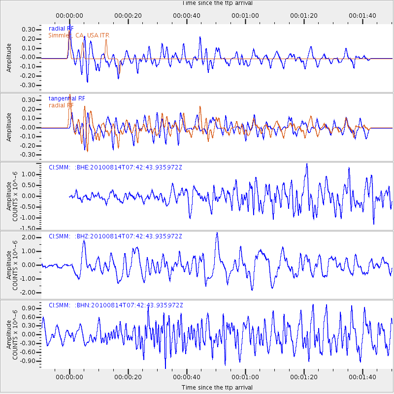
SMM Simmler, CA, USA - Earthquake Result Viewer
*The percent match for this event was below the threshold and hence no stack was calculated.
| Earthquake location: |
South Of Mariana Islands |
| Earthquake latitude/longitude: |
12.3/141.5 |
| Earthquake time(UTC): |
2010/08/14 (226) 07:30:16 GMT |
| Earthquake Depth: |
10 km |
| Earthquake Magnitude: |
6.0 MB, 6.0 MS, 6.2 MW, 6.1 MW |
| Earthquake Catalog/Contributor: |
WHDF/NEIC |
|
| Network: |
CI Caltech Regional Seismic Network |
| Station: |
SMM Simmler, CA, USA |
| Lat/Lon: |
35.31 N/120.00 W |
| Elevation: |
599 m |
|
| Distance: |
89.8 deg |
| Az: |
53.979 deg |
| Baz: |
284.896 deg |
| Ray Param: |
$rayparam |
*The percent match for this event was below the threshold and hence was not used in the summary stack. |
|
| Radial Match: |
79.047134 % |
| Radial Bump: |
400 |
| Transverse Match: |
80.93224 % |
| Transverse Bump: |
400 |
| SOD ConfigId: |
319893 |
| Insert Time: |
2011-01-05 21:46:13.383 +0000 |
| GWidth: |
2.5 |
| Max Bumps: |
400 |
| Tol: |
0.001 |
|
Signal To Noise
| Channel | StoN | STA | LTA |
| CI:SMM: :BHZ:20100814T07:42:43.935972Z | 9.008616 | 6.6330693E-7 | 7.363028E-8 |
| CI:SMM: :BHN:20100814T07:42:43.935972Z | 1.0010935 | 1.7523415E-7 | 1.7504274E-7 |
| CI:SMM: :BHE:20100814T07:42:43.935972Z | 1.5428741 | 2.0550057E-7 | 1.3319335E-7 |
| Arrivals |
| Ps | |
| PpPs | |
| PsPs/PpSs | |


