You are here: Home > Network List > CI - Caltech Regional Seismic Network Stations List
> Station BFS Mt Baldy Forest Station > Earthquake Result Viewer
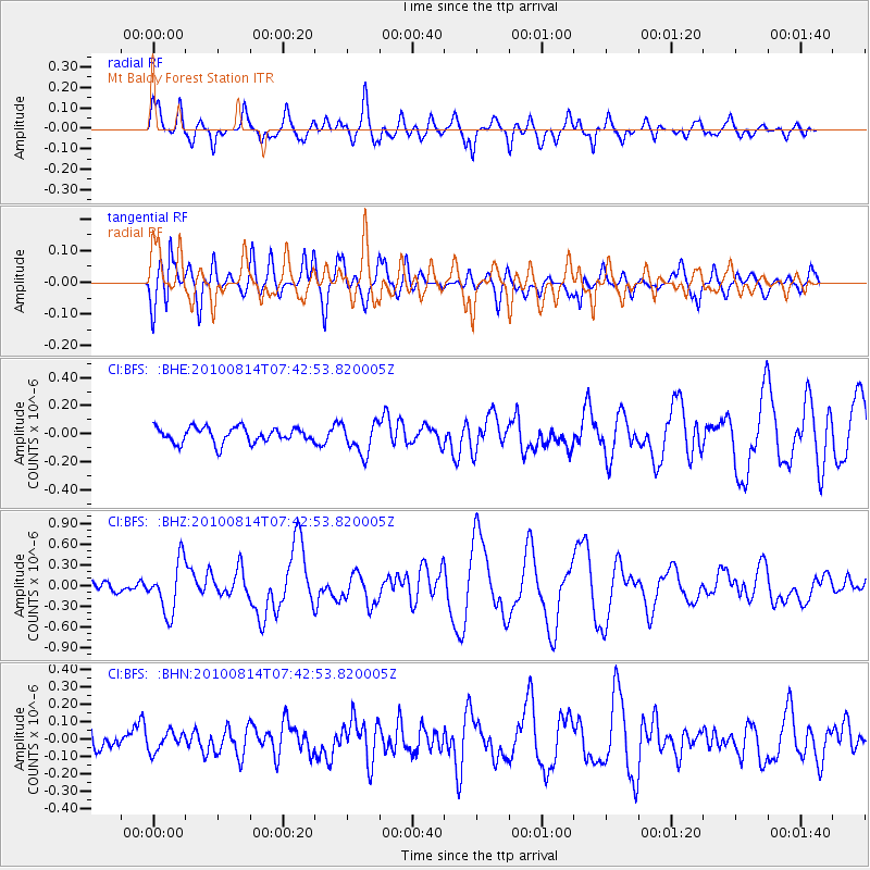
BFS Mt Baldy Forest Station - Earthquake Result Viewer
*The percent match for this event was below the threshold and hence no stack was calculated.
| Earthquake location: |
South Of Mariana Islands |
| Earthquake latitude/longitude: |
12.3/141.5 |
| Earthquake time(UTC): |
2010/08/14 (226) 07:30:16 GMT |
| Earthquake Depth: |
10 km |
| Earthquake Magnitude: |
6.0 MB, 6.0 MS, 6.2 MW, 6.1 MW |
| Earthquake Catalog/Contributor: |
WHDF/NEIC |
|
| Network: |
CI Caltech Regional Seismic Network |
| Station: |
BFS Mt Baldy Forest Station |
| Lat/Lon: |
34.24 N/117.66 W |
| Elevation: |
1312 m |
|
| Distance: |
91.9 deg |
| Az: |
54.497 deg |
| Baz: |
286.215 deg |
| Ray Param: |
$rayparam |
*The percent match for this event was below the threshold and hence was not used in the summary stack. |
|
| Radial Match: |
82.22514 % |
| Radial Bump: |
400 |
| Transverse Match: |
73.52234 % |
| Transverse Bump: |
400 |
| SOD ConfigId: |
319893 |
| Insert Time: |
2011-01-05 21:47:08.403 +0000 |
| GWidth: |
2.5 |
| Max Bumps: |
400 |
| Tol: |
0.001 |
|
Signal To Noise
| Channel | StoN | STA | LTA |
| CI:BFS: :BHZ:20100814T07:42:53.820005Z | 4.122913 | 3.6808822E-7 | 8.9278686E-8 |
| CI:BFS: :BHN:20100814T07:42:53.820005Z | 0.8211401 | 5.546396E-8 | 6.754506E-8 |
| CI:BFS: :BHE:20100814T07:42:53.820005Z | 2.0503883 | 1.1156539E-7 | 5.441183E-8 |
| Arrivals |
| Ps | |
| PpPs | |
| PsPs/PpSs | |


