You are here: Home > Network List > CI - Caltech Regional Seismic Network Stations List
> Station NEE2 Needles Airport > Earthquake Result Viewer
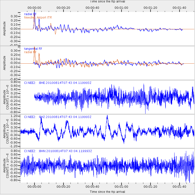
NEE2 Needles Airport - Earthquake Result Viewer
*The percent match for this event was below the threshold and hence no stack was calculated.
| Earthquake location: |
South Of Mariana Islands |
| Earthquake latitude/longitude: |
12.3/141.5 |
| Earthquake time(UTC): |
2010/08/14 (226) 07:30:16 GMT |
| Earthquake Depth: |
10 km |
| Earthquake Magnitude: |
6.0 MB, 6.0 MS, 6.2 MW, 6.1 MW |
| Earthquake Catalog/Contributor: |
WHDF/NEIC |
|
| Network: |
CI Caltech Regional Seismic Network |
| Station: |
NEE2 Needles Airport |
| Lat/Lon: |
34.77 N/114.62 W |
| Elevation: |
271 m |
|
| Distance: |
94.2 deg |
| Az: |
53.253 deg |
| Baz: |
287.996 deg |
| Ray Param: |
$rayparam |
*The percent match for this event was below the threshold and hence was not used in the summary stack. |
|
| Radial Match: |
78.01335 % |
| Radial Bump: |
400 |
| Transverse Match: |
66.024536 % |
| Transverse Bump: |
400 |
| SOD ConfigId: |
319893 |
| Insert Time: |
2011-01-05 21:48:03.985 +0000 |
| GWidth: |
2.5 |
| Max Bumps: |
400 |
| Tol: |
0.001 |
|
Signal To Noise
| Channel | StoN | STA | LTA |
| CI:NEE2: :BHZ:20100814T07:43:04.119993Z | 3.7882512 | 4.39449E-7 | 1.16003136E-7 |
| CI:NEE2: :BHN:20100814T07:43:04.119993Z | 0.99111503 | 2.1031221E-7 | 2.1219758E-7 |
| CI:NEE2: :BHE:20100814T07:43:04.119993Z | 1.7898197 | 2.883682E-7 | 1.6111576E-7 |
| Arrivals |
| Ps | |
| PpPs | |
| PsPs/PpSs | |


