You are here: Home > Network List > G - GEOSCOPE Stations List
> Station RER Riviere de l'Est, La Reunion (Indian Ocean) > Earthquake Result Viewer
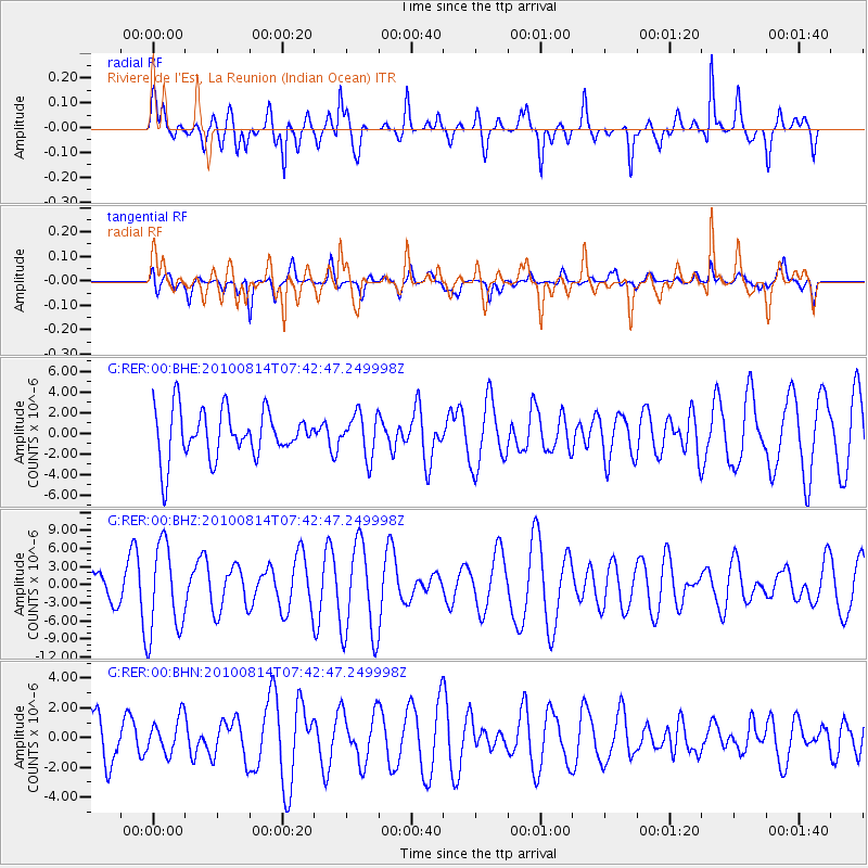
RER Riviere de l'Est, La Reunion (Indian Ocean) - Earthquake Result Viewer
*The percent match for this event was below the threshold and hence no stack was calculated.
| Earthquake location: |
South Of Mariana Islands |
| Earthquake latitude/longitude: |
12.3/141.5 |
| Earthquake time(UTC): |
2010/08/14 (226) 07:30:16 GMT |
| Earthquake Depth: |
10 km |
| Earthquake Magnitude: |
6.0 MB, 6.0 MS, 6.2 MW, 6.1 MW |
| Earthquake Catalog/Contributor: |
WHDF/NEIC |
|
| Network: |
G GEOSCOPE |
| Station: |
RER Riviere de l'Est, La Reunion (Indian Ocean) |
| Lat/Lon: |
21.16 S/55.75 E |
| Elevation: |
834 m |
|
| Distance: |
90.5 deg |
| Az: |
248.568 deg |
| Baz: |
77.034 deg |
| Ray Param: |
$rayparam |
*The percent match for this event was below the threshold and hence was not used in the summary stack. |
|
| Radial Match: |
64.66295 % |
| Radial Bump: |
400 |
| Transverse Match: |
50.06543 % |
| Transverse Bump: |
391 |
| SOD ConfigId: |
319893 |
| Insert Time: |
2011-01-05 21:48:53.277 +0000 |
| GWidth: |
2.5 |
| Max Bumps: |
400 |
| Tol: |
0.001 |
|
Signal To Noise
| Channel | StoN | STA | LTA |
| G:RER:00:BHZ:20100814T07:42:47.249998Z | 3.4298189 | 7.3662186E-6 | 2.147699E-6 |
| G:RER:00:BHN:20100814T07:42:47.249998Z | 1.070131 | 1.2216647E-6 | 1.141603E-6 |
| G:RER:00:BHE:20100814T07:42:47.249998Z | 0.87455976 | 2.0321788E-6 | 2.323659E-6 |
| Arrivals |
| Ps | |
| PpPs | |
| PsPs/PpSs | |


