You are here: Home > Network List > US - United States National Seismic Network Stations List
> Station EGMT Eagleton, Montana, USA > Earthquake Result Viewer
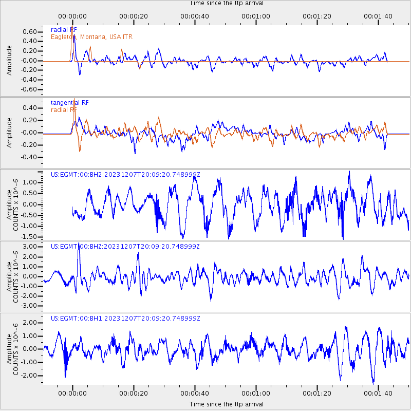
EGMT Eagleton, Montana, USA - Earthquake Result Viewer
*The percent match for this event was below the threshold and hence no stack was calculated.
| Earthquake location: |
Central Mexico |
| Earthquake latitude/longitude: |
18.4/-98.6 |
| Earthquake time(UTC): |
2023/12/07 (341) 20:03:38 GMT |
| Earthquake Depth: |
44 km |
| Earthquake Magnitude: |
5.8 mww |
| Earthquake Catalog/Contributor: |
NEIC PDE/us |
|
| Network: |
US United States National Seismic Network |
| Station: |
EGMT Eagleton, Montana, USA |
| Lat/Lon: |
48.02 N/109.75 W |
| Elevation: |
1055 m |
|
| Distance: |
30.9 deg |
| Az: |
345.304 deg |
| Baz: |
158.971 deg |
| Ray Param: |
$rayparam |
*The percent match for this event was below the threshold and hence was not used in the summary stack. |
|
| Radial Match: |
64.03938 % |
| Radial Bump: |
400 |
| Transverse Match: |
57.452126 % |
| Transverse Bump: |
400 |
| SOD ConfigId: |
33232451 |
| Insert Time: |
2023-12-21 20:20:11.471 +0000 |
| GWidth: |
2.5 |
| Max Bumps: |
400 |
| Tol: |
0.001 |
|
Signal To Noise
| Channel | StoN | STA | LTA |
| US:EGMT:00:BHZ:20231207T20:09:20.748999Z | 4.6677494 | 1.2161669E-6 | 2.6054673E-7 |
| US:EGMT:00:BH1:20231207T20:09:20.748999Z | 1.1276394 | 4.0577422E-7 | 3.5984394E-7 |
| US:EGMT:00:BH2:20231207T20:09:20.748999Z | 1.628844 | 6.485574E-7 | 3.981703E-7 |
| Arrivals |
| Ps | |
| PpPs | |
| PsPs/PpSs | |


