You are here: Home > Network List > UW - Pacific Northwest Regional Seismic Network Stations List
> Station MANO Manastash Observatory, WA, USA > Earthquake Result Viewer
MANO Manastash Observatory, WA, USA - Earthquake Result Viewer
| Earthquake location: |
Central Mexico |
| Earthquake latitude/longitude: |
18.4/-98.6 |
| Earthquake time(UTC): |
2023/12/07 (341) 20:03:38 GMT |
| Earthquake Depth: |
44 km |
| Earthquake Magnitude: |
5.8 mww |
| Earthquake Catalog/Contributor: |
NEIC PDE/us |
|
| Network: |
UW Pacific Northwest Regional Seismic Network |
| Station: |
MANO Manastash Observatory, WA, USA |
| Lat/Lon: |
46.95 N/120.72 W |
| Elevation: |
1200 m |
|
| Distance: |
33.8 deg |
| Az: |
332.317 deg |
| Baz: |
139.913 deg |
| Ray Param: |
0.07795431 |
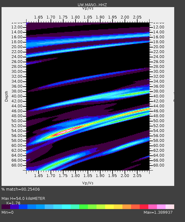
| Estimated Moho Depth: |
54.0 km |
| Estimated Crust Vp/Vs: |
1.76 |
| Assumed Crust Vp: |
6.597 km/s |
| Estimated Crust Vs: |
3.749 km/s |
| Estimated Crust Poisson's Ratio: |
0.26 |
|
| Radial Match: |
80.25406 % |
| Radial Bump: |
311 |
| Transverse Match: |
58.202324 % |
| Transverse Bump: |
400 |
| SOD ConfigId: |
33232451 |
| Insert Time: |
2023-12-21 20:21:47.195 +0000 |
| GWidth: |
2.5 |
| Max Bumps: |
400 |
| Tol: |
0.001 |
|

Signal To Noise
| Channel | StoN | STA | LTA |
| UW:MANO: :HHZ:20231207T20:09:45.840003Z | 4.250344 | 1.8857528E-6 | 4.4367061E-7 |
| UW:MANO: :HHN:20231207T20:09:45.840003Z | 0.9923078 | 6.326178E-7 | 6.3752174E-7 |
| UW:MANO: :HHE:20231207T20:09:45.840003Z | 1.0324687 | 7.2647697E-7 | 7.0363103E-7 |
| Arrivals |
| Ps | 6.8 SECOND |
| PpPs | 21 SECOND |
| PsPs/PpSs | 28 SECOND |


