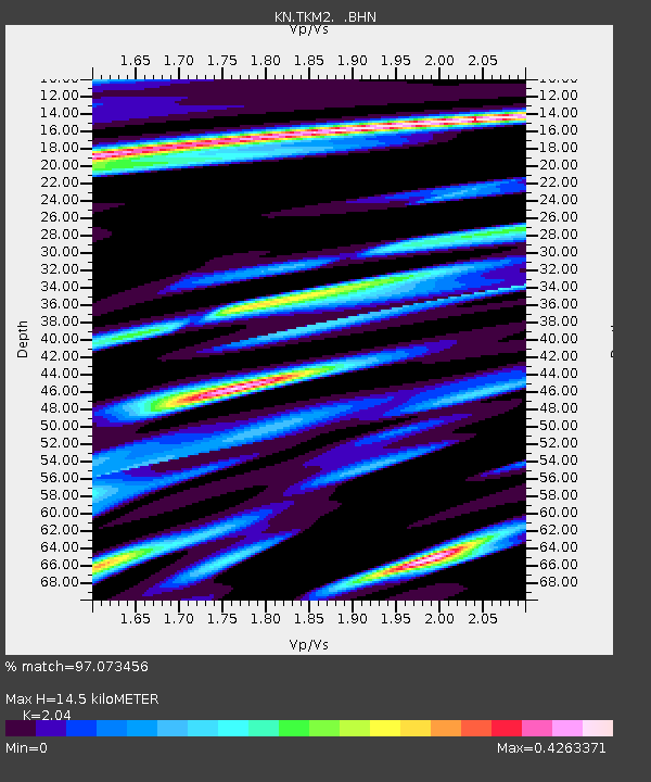
TKM2 KN.TKM2 - Earthquake Result Viewer
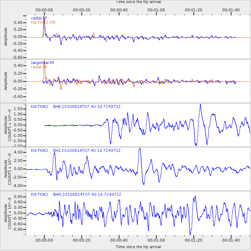
Earthquake location: South Of Mariana Islands
Earthquake latitude/longitude: 12.3/141.5
Earthquake time(UTC): 2010/08/14 (226) 07:30:16 GMT
Earthquake Depth: 10 km
Earthquake Magnitude: 6.0 MB, 6.0 MS, 6.2 MW, 6.1 MW
Earthquake Catalog/Contributor: WHDF/NEIC
Network: KN Kyrgyz Seismic Telemetry Network
Station: TKM2 KN.TKM2
Lat/Lon: 42.92 N/75.60 E
Elevation: 2020 m
Distance: 64.1 deg
Az: 311.79 deg
Baz: 97.331 deg
Ray Param: 0.059166588
Estimated Moho Depth: 14.5 km
Estimated Crust Vp/Vs: 2.04
Assumed Crust Vp: 6.306 km/s
Estimated Crust Vs: 3.091 km/s
Estimated Crust Poisson's Ratio: 0.34
Radial Match: 97.073456 %
Radial Bump: 400
Transverse Match: 89.31183 %
Transverse Bump: 400
SOD ConfigId: 319893
Insert Time: 2011-01-05 21:52:53.966 +0000
GWidth: 2.5
Max Bumps: 400
Tol: 0.001

Signal To Noise

ChannelStoNSTALTA
KN:TKM2: :BHZ:20100814T07:40:19.724973Z21.5909377.806708E-73.615734E-8
KN:TKM2: :BHN:20100814T07:40:19.724973Z1.52762165.6640726E-83.707772E-8
KN:TKM2: :BHE:20100814T07:40:19.724973Z14.4798523.035886E-72.0966278E-8
Arrivals
Ps2.5 SECOND
PpPs6.7 SECOND
PsPs/PpSs9.2 SECOND