You are here: Home > Network List > MY - Malaysian National Seismic Network Stations List
> Station IPM Ipoh > Earthquake Result Viewer
IPM Ipoh - Earthquake Result Viewer
| Earthquake location: |
South Of Mariana Islands |
| Earthquake latitude/longitude: |
12.3/141.5 |
| Earthquake time(UTC): |
2010/08/14 (226) 07:30:16 GMT |
| Earthquake Depth: |
10 km |
| Earthquake Magnitude: |
6.0 MB, 6.0 MS, 6.2 MW, 6.1 MW |
| Earthquake Catalog/Contributor: |
WHDF/NEIC |
|
| Network: |
MY Malaysian National Seismic Network |
| Station: |
IPM Ipoh |
| Lat/Lon: |
4.48 N/101.03 E |
| Elevation: |
247 m |
|
| Distance: |
40.7 deg |
| Az: |
262.483 deg |
| Baz: |
76.336 deg |
| Ray Param: |
0.07422516 |
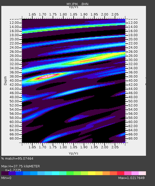
| Estimated Moho Depth: |
37.75 km |
| Estimated Crust Vp/Vs: |
1.72 |
| Assumed Crust Vp: |
6.468 km/s |
| Estimated Crust Vs: |
3.755 km/s |
| Estimated Crust Poisson's Ratio: |
0.25 |
|
| Radial Match: |
95.07464 % |
| Radial Bump: |
384 |
| Transverse Match: |
75.34943 % |
| Transverse Bump: |
400 |
| SOD ConfigId: |
319893 |
| Insert Time: |
2011-01-05 21:53:28.930 +0000 |
| GWidth: |
2.5 |
| Max Bumps: |
400 |
| Tol: |
0.001 |
|

Signal To Noise
| Channel | StoN | STA | LTA |
| MY:IPM: :BHZ:20100814T07:37:27.019987Z | 13.127358 | 1.4286302E-6 | 1.08828466E-7 |
| MY:IPM: :BHN:20100814T07:37:27.019987Z | 2.1992893 | 1.5798977E-7 | 7.183674E-8 |
| MY:IPM: :BHE:20100814T07:37:27.019987Z | 7.200893 | 7.028132E-7 | 9.760084E-8 |
| Arrivals |
| Ps | 4.5 SECOND |
| PpPs | 15 SECOND |
| PsPs/PpSs | 19 SECOND |


