You are here: Home > Network List > TA - USArray Transportable Network (new EarthScope stations) Stations List
> Station G24A Alzada, MT, USA > Earthquake Result Viewer
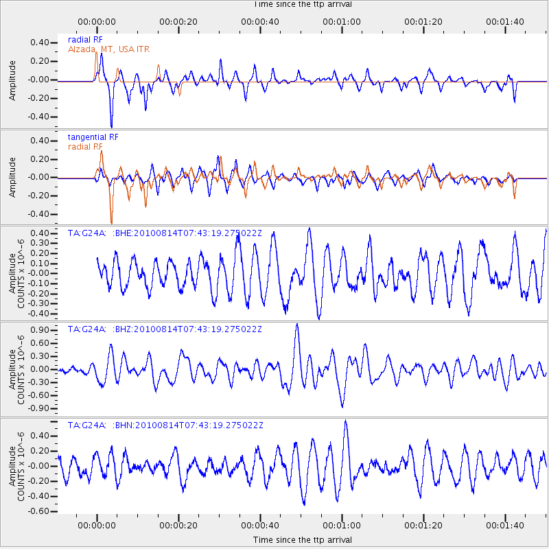
G24A Alzada, MT, USA - Earthquake Result Viewer
*The percent match for this event was below the threshold and hence no stack was calculated.
| Earthquake location: |
South Of Mariana Islands |
| Earthquake latitude/longitude: |
12.3/141.5 |
| Earthquake time(UTC): |
2010/08/14 (226) 07:30:16 GMT |
| Earthquake Depth: |
10 km |
| Earthquake Magnitude: |
6.0 MB, 6.0 MS, 6.2 MW, 6.1 MW |
| Earthquake Catalog/Contributor: |
WHDF/NEIC |
|
| Network: |
TA USArray Transportable Network (new EarthScope stations) |
| Station: |
G24A Alzada, MT, USA |
| Lat/Lon: |
45.33 N/104.42 W |
| Elevation: |
1147 m |
|
| Distance: |
97.5 deg |
| Az: |
40.507 deg |
| Baz: |
295.875 deg |
| Ray Param: |
$rayparam |
*The percent match for this event was below the threshold and hence was not used in the summary stack. |
|
| Radial Match: |
59.424683 % |
| Radial Bump: |
355 |
| Transverse Match: |
60.463047 % |
| Transverse Bump: |
400 |
| SOD ConfigId: |
319893 |
| Insert Time: |
2011-01-05 21:56:34.573 +0000 |
| GWidth: |
2.5 |
| Max Bumps: |
400 |
| Tol: |
0.001 |
|
Signal To Noise
| Channel | StoN | STA | LTA |
| TA:G24A: :BHZ:20100814T07:43:19.275022Z | 2.9521708 | 3.078432E-7 | 1.0427689E-7 |
| TA:G24A: :BHN:20100814T07:43:19.275022Z | 0.99236244 | 1.4696323E-7 | 1.4809432E-7 |
| TA:G24A: :BHE:20100814T07:43:19.275022Z | 1.8025699 | 2.0861968E-7 | 1.1573459E-7 |
| Arrivals |
| Ps | |
| PpPs | |
| PsPs/PpSs | |


