You are here: Home > Network List > US - United States National Seismic Network Stations List
> Station EGMT Eagleton, Montana, USA > Earthquake Result Viewer
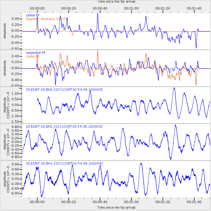
EGMT Eagleton, Montana, USA - Earthquake Result Viewer
*The percent match for this event was below the threshold and hence no stack was calculated.
| Earthquake location: |
Solomon Islands |
| Earthquake latitude/longitude: |
-8.4/157.2 |
| Earthquake time(UTC): |
2023/12/08 (342) 00:41:02 GMT |
| Earthquake Depth: |
10 km |
| Earthquake Magnitude: |
5.8 mww |
| Earthquake Catalog/Contributor: |
NEIC PDE/us |
|
| Network: |
US United States National Seismic Network |
| Station: |
EGMT Eagleton, Montana, USA |
| Lat/Lon: |
48.02 N/109.75 W |
| Elevation: |
1055 m |
|
| Distance: |
98.3 deg |
| Az: |
42.637 deg |
| Baz: |
266.637 deg |
| Ray Param: |
$rayparam |
*The percent match for this event was below the threshold and hence was not used in the summary stack. |
|
| Radial Match: |
41.50355 % |
| Radial Bump: |
400 |
| Transverse Match: |
46.74064 % |
| Transverse Bump: |
400 |
| SOD ConfigId: |
33232451 |
| Insert Time: |
2023-12-22 00:59:37.285 +0000 |
| GWidth: |
2.5 |
| Max Bumps: |
400 |
| Tol: |
0.001 |
|
Signal To Noise
| Channel | StoN | STA | LTA |
| US:EGMT:00:BHZ:20231208T00:54:08.100004Z | 0.7201598 | 2.1384292E-7 | 2.9693817E-7 |
| US:EGMT:00:BH1:20231208T00:54:08.100004Z | 1.4302632 | 6.793759E-7 | 4.7500066E-7 |
| US:EGMT:00:BH2:20231208T00:54:08.100004Z | 1.8575016 | 6.990433E-7 | 3.7633524E-7 |
| Arrivals |
| Ps | |
| PpPs | |
| PsPs/PpSs | |


