You are here: Home > Network List > TA - USArray Transportable Network (new EarthScope stations) Stations List
> Station J04D Umpqua National Forest, Toketee, OR, USA > Earthquake Result Viewer
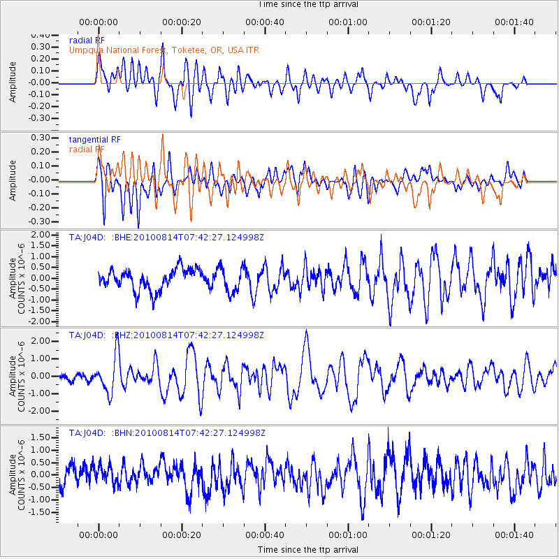
J04D Umpqua National Forest, Toketee, OR, USA - Earthquake Result Viewer
*The percent match for this event was below the threshold and hence no stack was calculated.
| Earthquake location: |
South Of Mariana Islands |
| Earthquake latitude/longitude: |
12.3/141.5 |
| Earthquake time(UTC): |
2010/08/14 (226) 07:30:16 GMT |
| Earthquake Depth: |
10 km |
| Earthquake Magnitude: |
6.0 MB, 6.0 MS, 6.2 MW, 6.1 MW |
| Earthquake Catalog/Contributor: |
WHDF/NEIC |
|
| Network: |
TA USArray Transportable Network (new EarthScope stations) |
| Station: |
J04D Umpqua National Forest, Toketee, OR, USA |
| Lat/Lon: |
43.24 N/122.11 W |
| Elevation: |
1948 m |
|
| Distance: |
86.3 deg |
| Az: |
46.7 deg |
| Baz: |
283.307 deg |
| Ray Param: |
$rayparam |
*The percent match for this event was below the threshold and hence was not used in the summary stack. |
|
| Radial Match: |
70.40467 % |
| Radial Bump: |
400 |
| Transverse Match: |
67.167595 % |
| Transverse Bump: |
400 |
| SOD ConfigId: |
319893 |
| Insert Time: |
2011-01-05 21:58:00.688 +0000 |
| GWidth: |
2.5 |
| Max Bumps: |
400 |
| Tol: |
0.001 |
|
Signal To Noise
| Channel | StoN | STA | LTA |
| TA:J04D: :BHZ:20100814T07:42:27.124998Z | 5.306846 | 1.1128126E-6 | 2.0969377E-7 |
| TA:J04D: :BHN:20100814T07:42:27.124998Z | 0.69634473 | 3.4001545E-7 | 4.882861E-7 |
| TA:J04D: :BHE:20100814T07:42:27.124998Z | 1.224126 | 5.8318926E-7 | 4.7641277E-7 |
| Arrivals |
| Ps | |
| PpPs | |
| PsPs/PpSs | |


