You are here: Home > Network List > TA - USArray Transportable Network (new EarthScope stations) Stations List
> Station K04D Chiloquin, OR, USA > Earthquake Result Viewer
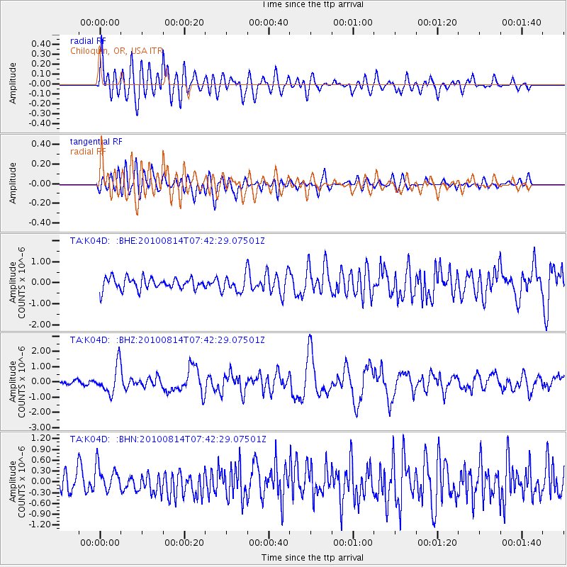
K04D Chiloquin, OR, USA - Earthquake Result Viewer
*The percent match for this event was below the threshold and hence no stack was calculated.
| Earthquake location: |
South Of Mariana Islands |
| Earthquake latitude/longitude: |
12.3/141.5 |
| Earthquake time(UTC): |
2010/08/14 (226) 07:30:16 GMT |
| Earthquake Depth: |
10 km |
| Earthquake Magnitude: |
6.0 MB, 6.0 MS, 6.2 MW, 6.1 MW |
| Earthquake Catalog/Contributor: |
WHDF/NEIC |
|
| Network: |
TA USArray Transportable Network (new EarthScope stations) |
| Station: |
K04D Chiloquin, OR, USA |
| Lat/Lon: |
42.62 N/121.75 W |
| Elevation: |
1315 m |
|
| Distance: |
86.6 deg |
| Az: |
47.239 deg |
| Baz: |
283.582 deg |
| Ray Param: |
$rayparam |
*The percent match for this event was below the threshold and hence was not used in the summary stack. |
|
| Radial Match: |
74.71844 % |
| Radial Bump: |
400 |
| Transverse Match: |
64.21895 % |
| Transverse Bump: |
400 |
| SOD ConfigId: |
319893 |
| Insert Time: |
2011-01-05 21:58:05.841 +0000 |
| GWidth: |
2.5 |
| Max Bumps: |
400 |
| Tol: |
0.001 |
|
Signal To Noise
| Channel | StoN | STA | LTA |
| TA:K04D: :BHZ:20100814T07:42:29.07501Z | 8.366971 | 9.4862924E-7 | 1.1337786E-7 |
| TA:K04D: :BHN:20100814T07:42:29.07501Z | 1.6393632 | 3.7477704E-7 | 2.2861137E-7 |
| TA:K04D: :BHE:20100814T07:42:29.07501Z | 1.4216915 | 3.9012832E-7 | 2.7441138E-7 |
| Arrivals |
| Ps | |
| PpPs | |
| PsPs/PpSs | |


