You are here: Home > Network List > TA - USArray Transportable Network (new EarthScope stations) Stations List
> Station L02D Cave Junction, OR, USA > Earthquake Result Viewer
L02D Cave Junction, OR, USA - Earthquake Result Viewer
| Earthquake location: |
South Of Mariana Islands |
| Earthquake latitude/longitude: |
12.3/141.5 |
| Earthquake time(UTC): |
2010/08/14 (226) 07:30:16 GMT |
| Earthquake Depth: |
10 km |
| Earthquake Magnitude: |
6.0 MB, 6.0 MS, 6.2 MW, 6.1 MW |
| Earthquake Catalog/Contributor: |
WHDF/NEIC |
|
| Network: |
TA USArray Transportable Network (new EarthScope stations) |
| Station: |
L02D Cave Junction, OR, USA |
| Lat/Lon: |
42.16 N/123.60 W |
| Elevation: |
458 m |
|
| Distance: |
85.4 deg |
| Az: |
48.003 deg |
| Baz: |
282.392 deg |
| Ray Param: |
0.04477921 |
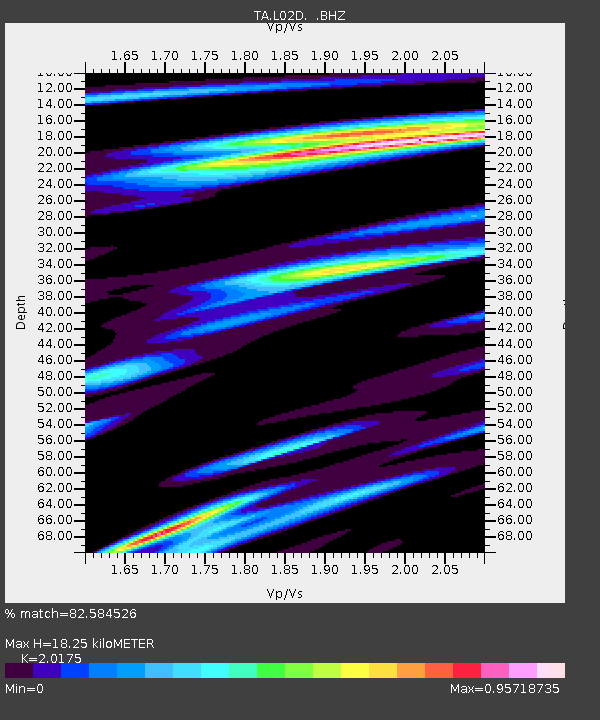
| Estimated Moho Depth: |
18.25 km |
| Estimated Crust Vp/Vs: |
2.02 |
| Assumed Crust Vp: |
6.522 km/s |
| Estimated Crust Vs: |
3.233 km/s |
| Estimated Crust Poisson's Ratio: |
0.34 |
|
| Radial Match: |
82.584526 % |
| Radial Bump: |
400 |
| Transverse Match: |
43.951935 % |
| Transverse Bump: |
400 |
| SOD ConfigId: |
319893 |
| Insert Time: |
2011-01-05 21:58:48.839 +0000 |
| GWidth: |
2.5 |
| Max Bumps: |
400 |
| Tol: |
0.001 |
|
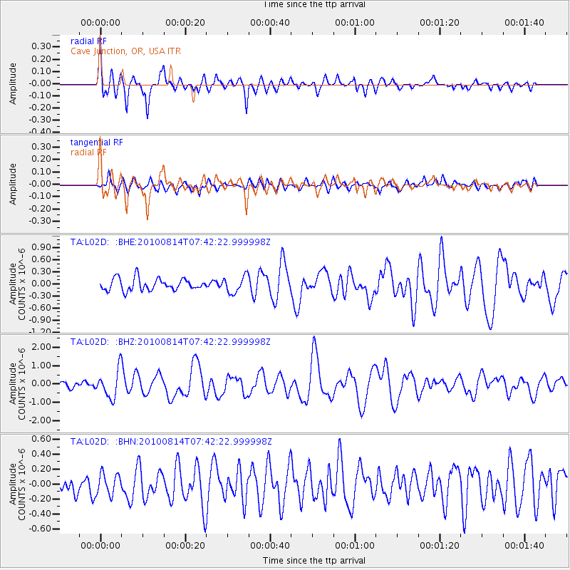
Signal To Noise
| Channel | StoN | STA | LTA |
| TA:L02D: :BHZ:20100814T07:42:22.999998Z | 2.9554543 | 7.7798103E-7 | 2.6323568E-7 |
| TA:L02D: :BHN:20100814T07:42:22.999998Z | 0.95504427 | 1.4948064E-7 | 1.5651698E-7 |
| TA:L02D: :BHE:20100814T07:42:22.999998Z | 1.4488623 | 2.1471216E-7 | 1.4819364E-7 |
| Arrivals |
| Ps | 2.9 SECOND |
| PpPs | 8.3 SECOND |
| PsPs/PpSs | 11 SECOND |


