You are here: Home > Network List > TA - USArray Transportable Network (new EarthScope stations) Stations List
> Station J01D Myrtle Point, OR, USA > Earthquake Result Viewer
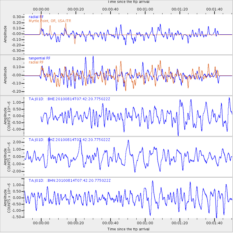
J01D Myrtle Point, OR, USA - Earthquake Result Viewer
*The percent match for this event was below the threshold and hence no stack was calculated.
| Earthquake location: |
South Of Mariana Islands |
| Earthquake latitude/longitude: |
12.3/141.5 |
| Earthquake time(UTC): |
2010/08/14 (226) 07:30:16 GMT |
| Earthquake Depth: |
10 km |
| Earthquake Magnitude: |
6.0 MB, 6.0 MS, 6.2 MW, 6.1 MW |
| Earthquake Catalog/Contributor: |
WHDF/NEIC |
|
| Network: |
TA USArray Transportable Network (new EarthScope stations) |
| Station: |
J01D Myrtle Point, OR, USA |
| Lat/Lon: |
43.16 N/123.93 W |
| Elevation: |
131 m |
|
| Distance: |
85.0 deg |
| Az: |
47.071 deg |
| Baz: |
282.092 deg |
| Ray Param: |
$rayparam |
*The percent match for this event was below the threshold and hence was not used in the summary stack. |
|
| Radial Match: |
67.963 % |
| Radial Bump: |
400 |
| Transverse Match: |
58.54732 % |
| Transverse Bump: |
400 |
| SOD ConfigId: |
319893 |
| Insert Time: |
2011-01-05 21:59:28.238 +0000 |
| GWidth: |
2.5 |
| Max Bumps: |
400 |
| Tol: |
0.001 |
|
Signal To Noise
| Channel | StoN | STA | LTA |
| TA:J01D: :BHZ:20100814T07:42:20.775022Z | 2.732286 | 1.1349307E-6 | 4.1537774E-7 |
| TA:J01D: :BHN:20100814T07:42:20.775022Z | 1.3111176 | 3.903093E-7 | 2.9769205E-7 |
| TA:J01D: :BHE:20100814T07:42:20.775022Z | 1.514848 | 4.2764904E-7 | 2.823049E-7 |
| Arrivals |
| Ps | |
| PpPs | |
| PsPs/PpSs | |


